Central France on alert for more violent storms
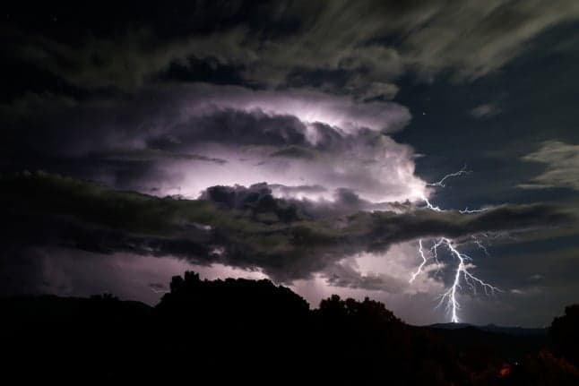
Four departments in central France were placed on storm alert on Monday, as France braces itself for another week of extreme weather.
The Allier, Puy-de-Dôme, Loire and Rhône departments have been placed on orange alert, based on forecasts by Météo France. 'Violent' storms were expected to begin on Monday afternoon, with hailstorms, heavy rain and strong winds.
🔶 4 dpts en #vigilanceOrange
Restez informés sur https://t.co/rJ24zzmmy4 pic.twitter.com/DeAP97zBmW
— VigiMétéoFrance (@VigiMeteoFrance) June 28, 2021
On Tuesday, June 22nd, three months’ worth of rain fell in one day in the northern town of Beauvais, leading to floods and collisions on the roads. While on Friday, June 18th, thousands of homes in south west France were without electricity after violent overnight storms after an early summer heatwave ended with a thunderous bang.
And after a brief respite there was more on the way - starting on Saturday as the 2021 Tour de France got under way in Brittany.
Storms in the south west caused damage to trees and power lines on Sunday.
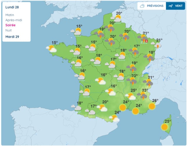
The Météo-France forecast for Monday evening. Image: Météo-France
Forecasters said the cause of this latest series of thunderstorms is a weather phenomenon known as a ‘cold drop’ - a mass of isolated cold air surrounded by areas of warmer air.
Une goutte froide va nous occuper ces 7 prochains jours avec des #orages quotidiens prévus, parfois forts entre dimanche et mardi notamment.
Une évacuation du système est envisagée en fin de semaine prochaine, à confirmer. pic.twitter.com/qGludDK4aI
— Keraunos (@KeraunosObs) June 24, 2021
As the animation from storm watchers Keraunos shows, that problematic mass of storm-causing cold air that has travelled from Britain is expected to bounce around France for several days.
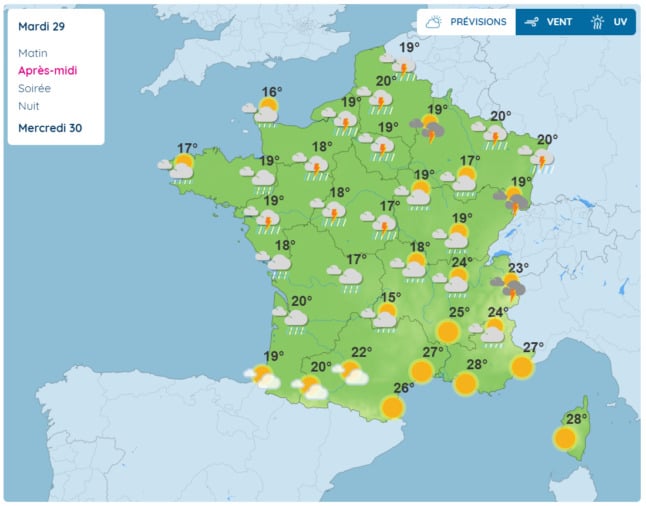
The Météo-France forecast for Tuesday afternoon. Image: Météo-France
Temperatures will stick below normal for the season for most of the country, while forecasters expect storms to bubble up towards the end of the day from Monday until at least Thursday.
Forecasters admit the scenario could change a bit depending on the behaviour of the cold drop, which may disappear faster than models predict. But the consensus of opinion is that we should expect rain and storms for a few days to come.
Storms are not unusual at this time of year - they are most common in France in June, July and August, with an average of 15 to 20 stormy days each summer. We will be at the lower end of that average by the end of next week.
Comments
See Also
The Allier, Puy-de-Dôme, Loire and Rhône departments have been placed on orange alert, based on forecasts by Météo France. 'Violent' storms were expected to begin on Monday afternoon, with hailstorms, heavy rain and strong winds.
🔶 4 dpts en #vigilanceOrange
— VigiMétéoFrance (@VigiMeteoFrance) June 28, 2021
Restez informés sur https://t.co/rJ24zzmmy4 pic.twitter.com/DeAP97zBmW
On Tuesday, June 22nd, three months’ worth of rain fell in one day in the northern town of Beauvais, leading to floods and collisions on the roads. While on Friday, June 18th, thousands of homes in south west France were without electricity after violent overnight storms after an early summer heatwave ended with a thunderous bang.
And after a brief respite there was more on the way - starting on Saturday as the 2021 Tour de France got under way in Brittany.
Storms in the south west caused damage to trees and power lines on Sunday.
The Météo-France forecast for Monday evening. Image: Météo-France
Forecasters said the cause of this latest series of thunderstorms is a weather phenomenon known as a ‘cold drop’ - a mass of isolated cold air surrounded by areas of warmer air.
Une goutte froide va nous occuper ces 7 prochains jours avec des #orages quotidiens prévus, parfois forts entre dimanche et mardi notamment.
— Keraunos (@KeraunosObs) June 24, 2021
Une évacuation du système est envisagée en fin de semaine prochaine, à confirmer. pic.twitter.com/qGludDK4aI
As the animation from storm watchers Keraunos shows, that problematic mass of storm-causing cold air that has travelled from Britain is expected to bounce around France for several days.
The Météo-France forecast for Tuesday afternoon. Image: Météo-France
Temperatures will stick below normal for the season for most of the country, while forecasters expect storms to bubble up towards the end of the day from Monday until at least Thursday.
Forecasters admit the scenario could change a bit depending on the behaviour of the cold drop, which may disappear faster than models predict. But the consensus of opinion is that we should expect rain and storms for a few days to come.
Storms are not unusual at this time of year - they are most common in France in June, July and August, with an average of 15 to 20 stormy days each summer. We will be at the lower end of that average by the end of next week.
Join the conversation in our comments section below. Share your own views and experience and if you have a question or suggestion for our journalists then email us at [email protected].
Please keep comments civil, constructive and on topic – and make sure to read our terms of use before getting involved.
Please log in here to leave a comment.