MAP: The French towns at urgent risk from coastal erosion
The French government has published a new report listing the towns and cities most at risk from coastal erosion.
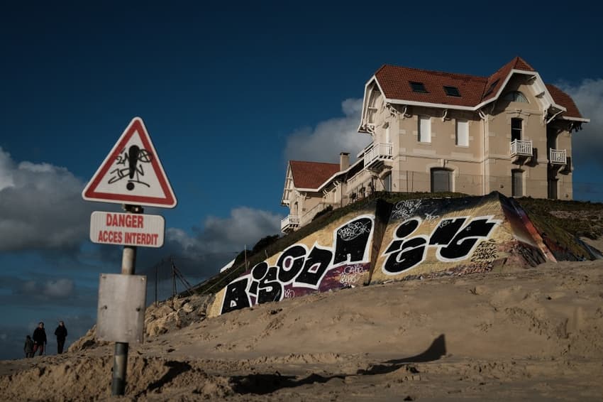
A recent government report found that 126 French municipalities, or the equivalent of one fifth of the French coastline, are at high risk of coastal erosion.
The majority of these are located on the Western coast of the country, with 41 in Brittany, 16 in Normandy, 31 in New Aquitaine.
Le gouvernement a publié les noms des 126 communes françaises qui auront l'obligation de s'adapter en priorité à l'érosion du littoral aggravée par le réchauffement climatique et la pression humaine ⬇️ #AFP #AFPGraphics pic.twitter.com/D1jvPObwYd
— Agence France-Presse (@afpfr) May 4, 2022
They include popular holiday sports such as Biarritz, La-Tranche-sur-Mer and Saint-Jean-de-Luz.
The new Climate and Resilience law, will now require affected municipalities to make key changes in order to adapt to climate change. Specifically, mayors will have to commission maps that predict the risk of coastal recession for 30 years in the future, and then again for 100 years in the future. These maps will serve as a basis for new rules of regarding land use, including new regulations on construction.
Overall, 864 municipalities are listed as "particularly vulnerable," with the 126 shown above are considered as highly vulnerable. The list of impacted communities will be updated every nine years.
🌊 #MontéeDesEaux
Votre ville ou votre plage sont-elles menacées par le réchauffement climatique ?
👉https://t.co/l6gCFXQZC7 pic.twitter.com/S2s3kxggVH
— franceinfo plus (@franceinfoplus) October 29, 2021
In France, 1.5 million people live in these zones, meaning they are at particular risk for violent storms and flooding.
Cette carte publiée par l'Agence européenne de l'environnement en 2020 détaille les zones littorales françaises les plus exposées à la montée de niveau de la mer. pic.twitter.com/LqG6XQVhY1
— Samuel GREE (@SamuelGREE1) August 12, 2021
READ MORE: MAP: Where in France is most at risk from erosion and rising sea levels
How does coastal erosion work?
Coastal erosion is largely impacted by global sea level rise, and the "hardness" of the shore plays a role in how rapidly the coastline is able to be eroded (take a sandy shoreline versus one with cliffs).
This infographic by French daily Le Parisien helps explain the causes of coastal erosion.
Comment l’érosion fait disparaître nos plages >> https://t.co/GFNF18UwQo #littoral pic.twitter.com/dMTJPZKdNx
— Le Parisien | infographies (@leparisieninfog) August 15, 2019
You can find the full list of at-risk communities here.
Comments
See Also
A recent government report found that 126 French municipalities, or the equivalent of one fifth of the French coastline, are at high risk of coastal erosion.
The majority of these are located on the Western coast of the country, with 41 in Brittany, 16 in Normandy, 31 in New Aquitaine.
Le gouvernement a publié les noms des 126 communes françaises qui auront l'obligation de s'adapter en priorité à l'érosion du littoral aggravée par le réchauffement climatique et la pression humaine ⬇️ #AFP #AFPGraphics pic.twitter.com/D1jvPObwYd
— Agence France-Presse (@afpfr) May 4, 2022
They include popular holiday sports such as Biarritz, La-Tranche-sur-Mer and Saint-Jean-de-Luz.
The new Climate and Resilience law, will now require affected municipalities to make key changes in order to adapt to climate change. Specifically, mayors will have to commission maps that predict the risk of coastal recession for 30 years in the future, and then again for 100 years in the future. These maps will serve as a basis for new rules of regarding land use, including new regulations on construction.
Overall, 864 municipalities are listed as "particularly vulnerable," with the 126 shown above are considered as highly vulnerable. The list of impacted communities will be updated every nine years.
🌊 #MontéeDesEaux
— franceinfo plus (@franceinfoplus) October 29, 2021
Votre ville ou votre plage sont-elles menacées par le réchauffement climatique ?
👉https://t.co/l6gCFXQZC7 pic.twitter.com/S2s3kxggVH
In France, 1.5 million people live in these zones, meaning they are at particular risk for violent storms and flooding.
Cette carte publiée par l'Agence européenne de l'environnement en 2020 détaille les zones littorales françaises les plus exposées à la montée de niveau de la mer. pic.twitter.com/LqG6XQVhY1
— Samuel GREE (@SamuelGREE1) August 12, 2021
READ MORE: MAP: Where in France is most at risk from erosion and rising sea levels
How does coastal erosion work?
Coastal erosion is largely impacted by global sea level rise, and the "hardness" of the shore plays a role in how rapidly the coastline is able to be eroded (take a sandy shoreline versus one with cliffs).
This infographic by French daily Le Parisien helps explain the causes of coastal erosion.
Comment l’érosion fait disparaître nos plages >> https://t.co/GFNF18UwQo #littoral pic.twitter.com/dMTJPZKdNx
— Le Parisien | infographies (@leparisieninfog) August 15, 2019
You can find the full list of at-risk communities here.
Join the conversation in our comments section below. Share your own views and experience and if you have a question or suggestion for our journalists then email us at [email protected].
Please keep comments civil, constructive and on topic – and make sure to read our terms of use before getting involved.
Please log in here to leave a comment.