MAP: Where in France is most at risk from erosion and rising sea levels
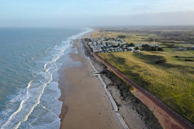
Rising sea levels and coastal erosion have encroached upon a fifth of France's coastline. A new map reveals the coastal areas which have already begun to disappear.
Ahead of the COP26 climate summit in Glasgow, news site franceinfo has published an interactive map showing the areas of France which have been most affected by coastal erosion.
The map relies on data from the Centre for Studies and Expertise on Risks, the Environment, Mobility and Urban Planning (Cerema), which published a report in 2018 comparing aerial photos taken between 1920 and 1957 with more recent images.
The study found that 18.6 percent of France's coastline had retreated in that time, while 11.7 percent had advanced, and the majority had undergone no change. Overall, 523 towns and villages included at least one area affected by coastal retreat, and 59 of them recorded erosion of over 1.5 metres per year along certain stretches.
The map from franceinfo shows the overall situation at a département level, but it is also possible to search for a specific coastal town and see how it has been affected - click HERE for the interactive map.
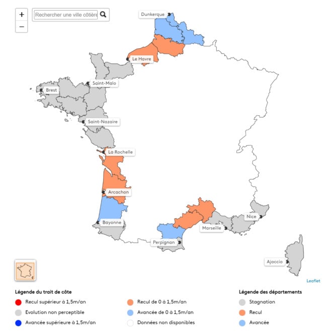
Map showing the départements (in orange) where the average coastline has retreated. Image: franceinfo
Much depends on the nature of the coastline. In areas defined by cliffs, which represent slightly more than half of French coastal areas, only 6 percent have been impacted by coastal erosion, compared to 37 percent of sandy coastline.
Which explains why Brittany has so far come out largely unscathed. South-west France on the other hand has been significantly affected - Gironde is the département with the largest stretches of retreating coastline, and nearby Charente-Maritime is third. Manche in Normandy is in second place, while other areas in the north and parts of the Mediterranean coast have also suffered.
READ ALSO Climate change: What can we expect future French summers to look like?
According to Cerema's estimates, Gironde lost 5.59 square kilometres of land between 1960 and 2010, with Charente-Maritime and Bouches-du-Rhône also losing more than 5 square kilometres each. Overall, the areas of coastline affected in that 50-year period are estimated at 30 square kilometres, the size of La Rochelle.
As part of franceinfo's report, it is also possible to compare aerial photos of La Tremblade on the Atlantic coast, where "certain dunes suffered a record retreat of 7.9 metres per year between 1945 and 2010".
Cerema has estimated that between 5,000 and 47,300 homes in France could fall victim to coastal erosion by the year 2100, franceinfo reports.
Meanwhile, the map below from American organisation Climate Central shows the areas in France (and around the world) with an unobstructed path to the sea which are less than one metre above water level, and therefore potentially vulnerable to sea level rises.
A recent report from the Intergovernmental Panel on Climate Change concluded that it is "virtually certain that global mean sea level will continue to rise over the 21st century", with further rises of between 28 cm and 1 metre to be expected globally by the end of the century.
Comments
See Also
Ahead of the COP26 climate summit in Glasgow, news site franceinfo has published an interactive map showing the areas of France which have been most affected by coastal erosion.
The map relies on data from the Centre for Studies and Expertise on Risks, the Environment, Mobility and Urban Planning (Cerema), which published a report in 2018 comparing aerial photos taken between 1920 and 1957 with more recent images.
The study found that 18.6 percent of France's coastline had retreated in that time, while 11.7 percent had advanced, and the majority had undergone no change. Overall, 523 towns and villages included at least one area affected by coastal retreat, and 59 of them recorded erosion of over 1.5 metres per year along certain stretches.
The map from franceinfo shows the overall situation at a département level, but it is also possible to search for a specific coastal town and see how it has been affected - click HERE for the interactive map.
Much depends on the nature of the coastline. In areas defined by cliffs, which represent slightly more than half of French coastal areas, only 6 percent have been impacted by coastal erosion, compared to 37 percent of sandy coastline.
Which explains why Brittany has so far come out largely unscathed. South-west France on the other hand has been significantly affected - Gironde is the département with the largest stretches of retreating coastline, and nearby Charente-Maritime is third. Manche in Normandy is in second place, while other areas in the north and parts of the Mediterranean coast have also suffered.
READ ALSO Climate change: What can we expect future French summers to look like?
According to Cerema's estimates, Gironde lost 5.59 square kilometres of land between 1960 and 2010, with Charente-Maritime and Bouches-du-Rhône also losing more than 5 square kilometres each. Overall, the areas of coastline affected in that 50-year period are estimated at 30 square kilometres, the size of La Rochelle.
As part of franceinfo's report, it is also possible to compare aerial photos of La Tremblade on the Atlantic coast, where "certain dunes suffered a record retreat of 7.9 metres per year between 1945 and 2010".
Cerema has estimated that between 5,000 and 47,300 homes in France could fall victim to coastal erosion by the year 2100, franceinfo reports.
Meanwhile, the map below from American organisation Climate Central shows the areas in France (and around the world) with an unobstructed path to the sea which are less than one metre above water level, and therefore potentially vulnerable to sea level rises.
A recent report from the Intergovernmental Panel on Climate Change concluded that it is "virtually certain that global mean sea level will continue to rise over the 21st century", with further rises of between 28 cm and 1 metre to be expected globally by the end of the century.
Join the conversation in our comments section below. Share your own views and experience and if you have a question or suggestion for our journalists then email us at [email protected].
Please keep comments civil, constructive and on topic – and make sure to read our terms of use before getting involved.
Please log in here to leave a comment.