Snow causes transport chaos across south of France
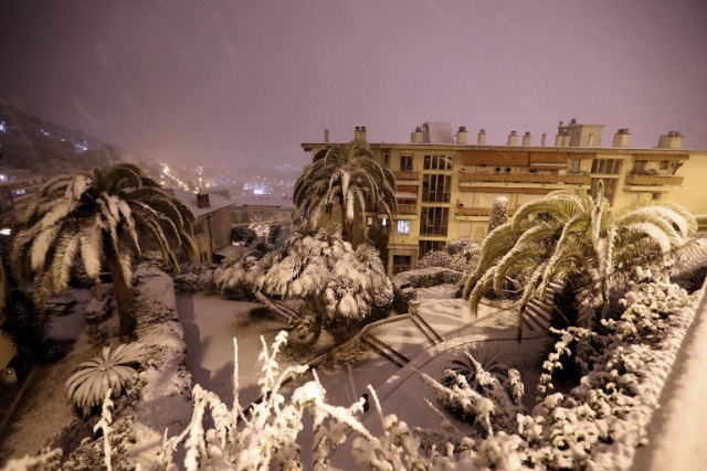
Snowfall cased transport chaos across the south of France on Wednesday night and Thursday morning and left hundreds of motorists stranded on motorways overnight in the south west.
Main info:
-
56 departments on orange alert (mostly for snow and ice)
-
Hundreds of motorists trapped on motorway near Montpellier overnight on Wednesday
-
Flights cancelled at airports in southern France
-
People around Paris region advised not to drive due to snow
-
Temperatures in south west are set to rise steeply throughout Thursday.
-
READ ALSO: The pictures that show just how cold it is in France
In total, 56 departments in the south, west, central and eastern parts of the country were on orange alert -- the second highest warning -- mainly for snow and ice, as well as violent winds and floods on Thursday morning.
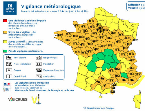
Map: Meteo France
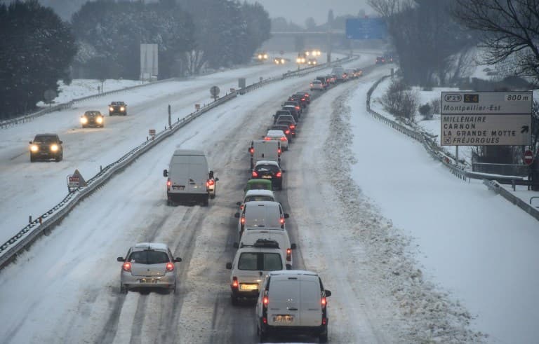
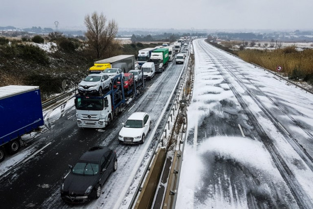
As promised overnight on Wednesday a thin layer of snow coated northern France, while around 20 cm of snow caused chaos in the south west on Wednesday evening. The department of Herault had been placed on red alert due to heavy snow.
Some 2,000 motorists were left stranded for hours on roads near the city of Montpellier on Wednesday night. One motorist told France info on Thursday morning he had been stuck on the A9 motorway for 24 hours, with rescue services promising to evacuate him on Wednesday night. He was still waiting at 8am on Thursday morning.
Many were evacuated and spent the night in emergency shelters around the region.
The A9 remained closed between Orange and Narbonne on Tursday morning which also provoked huge tailbacks on the A7 in Vaucluse.
Motorway authorities blamed truck drivers for not adhering to restrictions that were put in place on Wednesday that barred them from travelling on main routes.
By Thursday morning it was raining in Montpellier but the city's streets remained blanketed in snow meaning public transport had effectively ground to a halt.
Authorities told motorists not to get in their cars for fear of worsening the blockages on roads. "Everything is blocked on Thursday morning in Montpellier, there's no buses and no trams,"on official told French media.
#Montpellier enseveli sous la #neige ce matin. Mais les fortes pluies et le redoux rapide en cours provoquent d'intenses #ruissellements et des risques ponctuels d'#inondations près des points bas jusqu'à demain. Source : Youtube /
Cricri Cricri pic.twitter.com/NjEp3kRHBC
— La Chaîne Météo (@lachainemeteo) March 1, 2018
As for the rest of the country, light snowfall was only causing minor disruption from Brittany across to he greater Paris region of Île-de-France.
In Ile-de-France, where 1-3 cm of snow was expected, the police have "strongly advised against using their cars" until Thursday at 2pm. Most public transport services were running as normal.
Réveil sous une très fine pellicule de neige à #Paris avec 1 cm au sol, bien loin des 12 cm mesurés lors de la la chute de neige du 7 février dernier dans la capitale ! Source : https://t.co/K5Ufy6aENx pic.twitter.com/3rwRa0juAi
— La Chaîne Météo (@lachainemeteo) March 1, 2018
Several airports announced closures and delays including Montpellier, Pau and Biarritz. Geneva airport in the south east remained closed until further notice. Passengers were being advised not to travel to the airport until further notice.
#neige Le tramway de #Dijon circule au ralenti https://t.co/vZyUh5uAEx pic.twitter.com/q5cfvcxMdd
— France 3 Bourgogne (@F3Bourgogne) March 1, 2018
❄ La neige est tombée sur la Bretagne ! Et chez vous, c'est comment ?https://t.co/E2c0CPTZRY pic.twitter.com/aGsq58bYjg
— Ouest-France (@OuestFrance) March 1, 2018
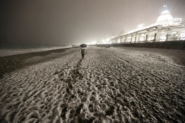
In the Riviera resort of Nice snow transformed the beach on Wednesday night.
Temperatures were set to rise quite steeply in the south west throughout Thursday to bring an abrupt end to the big chill. However in the north of the country it will take a while longer to warm up.
In the north of the country minimum temperatures on Thursday are expected to be -2C to -5C with highs of 4C to 9C.
Meanwhile in the south the lowest temperatures are expected to be 1C to 5C with maximum temperatures of 17C.
This image below from Biarritz in the south west shows the difference 24 hours can make. On Wednesday morning the beach was covered in thic snow but by Thursday morning the snow had gone as temperatures warmed.
Hier, #Biarritz se réveillait sous 10 cm de #neige et -4°C. Ce matin, il fait 11°C au thermomètre. La #neige a fondu. Le passage de l'#hiver au printemps a été rapide. Et ça tombe bien puisque ce jeudi 1er mars correspond au début du #printemps météorologique. pic.twitter.com/geoiqy28bl
— La Chaîne Météo (@lachainemeteo) March 1, 2018
Comments
See Also
Main info:
- 56 departments on orange alert (mostly for snow and ice)
- Hundreds of motorists trapped on motorway near Montpellier overnight on Wednesday
- Flights cancelled at airports in southern France
- People around Paris region advised not to drive due to snow
- Temperatures in south west are set to rise steeply throughout Thursday.
- READ ALSO: The pictures that show just how cold it is in France
In total, 56 departments in the south, west, central and eastern parts of the country were on orange alert -- the second highest warning -- mainly for snow and ice, as well as violent winds and floods on Thursday morning.
Map: Meteo France
As promised overnight on Wednesday a thin layer of snow coated northern France, while around 20 cm of snow caused chaos in the south west on Wednesday evening. The department of Herault had been placed on red alert due to heavy snow.
Some 2,000 motorists were left stranded for hours on roads near the city of Montpellier on Wednesday night. One motorist told France info on Thursday morning he had been stuck on the A9 motorway for 24 hours, with rescue services promising to evacuate him on Wednesday night. He was still waiting at 8am on Thursday morning.
Many were evacuated and spent the night in emergency shelters around the region.
The A9 remained closed between Orange and Narbonne on Tursday morning which also provoked huge tailbacks on the A7 in Vaucluse.
Motorway authorities blamed truck drivers for not adhering to restrictions that were put in place on Wednesday that barred them from travelling on main routes.
#Montpellier enseveli sous la #neige ce matin. Mais les fortes pluies et le redoux rapide en cours provoquent d'intenses #ruissellements et des risques ponctuels d'#inondations près des points bas jusqu'à demain. Source : Youtube /
— La Chaîne Météo (@lachainemeteo) March 1, 2018
Cricri Cricri pic.twitter.com/NjEp3kRHBC
As for the rest of the country, light snowfall was only causing minor disruption from Brittany across to he greater Paris region of Île-de-France.
In Ile-de-France, where 1-3 cm of snow was expected, the police have "strongly advised against using their cars" until Thursday at 2pm. Most public transport services were running as normal.
Réveil sous une très fine pellicule de neige à #Paris avec 1 cm au sol, bien loin des 12 cm mesurés lors de la la chute de neige du 7 février dernier dans la capitale ! Source : https://t.co/K5Ufy6aENx pic.twitter.com/3rwRa0juAi
— La Chaîne Météo (@lachainemeteo) March 1, 2018
Several airports announced closures and delays including Montpellier, Pau and Biarritz. Geneva airport in the south east remained closed until further notice. Passengers were being advised not to travel to the airport until further notice.
#neige Le tramway de #Dijon circule au ralenti https://t.co/vZyUh5uAEx pic.twitter.com/q5cfvcxMdd
— France 3 Bourgogne (@F3Bourgogne) March 1, 2018
❄ La neige est tombée sur la Bretagne ! Et chez vous, c'est comment ?https://t.co/E2c0CPTZRY pic.twitter.com/aGsq58bYjg
— Ouest-France (@OuestFrance) March 1, 2018
In the Riviera resort of Nice snow transformed the beach on Wednesday night.
Temperatures were set to rise quite steeply in the south west throughout Thursday to bring an abrupt end to the big chill. However in the north of the country it will take a while longer to warm up.
Hier, #Biarritz se réveillait sous 10 cm de #neige et -4°C. Ce matin, il fait 11°C au thermomètre. La #neige a fondu. Le passage de l'#hiver au printemps a été rapide. Et ça tombe bien puisque ce jeudi 1er mars correspond au début du #printemps météorologique. pic.twitter.com/geoiqy28bl
— La Chaîne Météo (@lachainemeteo) March 1, 2018
Join the conversation in our comments section below. Share your own views and experience and if you have a question or suggestion for our journalists then email us at [email protected].
Please keep comments civil, constructive and on topic – and make sure to read our terms of use before getting involved.
Please log in here to leave a comment.