Northern France on weather alert for high winds and storms
Over two dozen French départements - including Paris - have been placed on weather warnings on Thursday and train services in some areas have been suspended as Storm Louis gains traction in northern France.
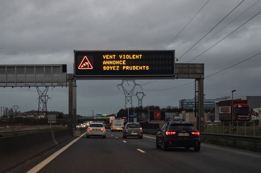
France's national weather service, Météo France placed 26 départements on the orange weather alert (the second highest rating) for high winds and heavy rain/flooding in its Thursday morning bulletin.
Storm Louis (Tempête Louis) was gaining traction on Thursday morning in the Channel and along the northern coast of France. It was expected to intensify in the afternoon around 4pm, bringing with it large gusts of wind in the northern half of the country.
Of the 26 départements on the orange weather alert, 24 were listed for 'violent winds'.
These are; Aisne, Ardennes, Calvados, Eure, Eure-et-Loir, Hautes-Pyrénées, Manche, Marne, Meuse, Nord, Oise, Orne, Pas-de-Calais, Paris, Pyrénées-Atlantiques, Seine-Maritime, Seine-et-Marne, Yvelines, Somme, Essonne, Hauts-de-Seine, Seine-Saint-Denis, Val-de-Marne and Val-d'Oise.
According to Météo France, gusts could reach between 90 to 110km inland. Along the coast, they could go up to 120 to 130km.
🔶 26 départements en Orange (https://t.co/CSYEovTI83) pic.twitter.com/YsX7goRgH3
— VigiMétéoFrance (@VigiMeteoFrance) February 22, 2024
Further to the south, the départements of Deux-Sèvres and Vendée were placed on orange alert for heavy rains, which were set to start in the morning and continue until mid-afternoon.
Météo France warned that about 30 to 50mm of precipitation were expected, going up to 60mm locally.
Cancelled trains
French national rail services suspended some trains in northern parts of the country due to expected weather conditions.
The TER (regional train) lines in Hauts-de-France, including Béthune-St Pol sur Ternoise, Arras-St Pol sur Ternoise, Beauvais-Abancourt le Tréport, Amiens-Compiègne, Creil-Beauvais and Paris-Laon, were all cancelled on Thursday.
In Brittany, some disruption was also expected along the Quimper-Brest and St Brieuc-Lannion lines due to the risk of strong winds.
Traffic was expected to resume again on Friday morning, SNCF told Ouest France.
Des #orages très localisés seront possibles au passage du front froid ce jeudi.
Ils pourront générer des rafales convectives > 100 km/h et un faible risque de tornade.
La nuit prochaine, la traîne se déploie par l'ouest : https://t.co/dookCX0aeA #Louis #TempeteLouis pic.twitter.com/b3sAXmwRP9
— Keraunos (@KeraunosObs) February 22, 2024
Comments
See Also
France's national weather service, Météo France placed 26 départements on the orange weather alert (the second highest rating) for high winds and heavy rain/flooding in its Thursday morning bulletin.
Storm Louis (Tempête Louis) was gaining traction on Thursday morning in the Channel and along the northern coast of France. It was expected to intensify in the afternoon around 4pm, bringing with it large gusts of wind in the northern half of the country.
Of the 26 départements on the orange weather alert, 24 were listed for 'violent winds'.
These are; Aisne, Ardennes, Calvados, Eure, Eure-et-Loir, Hautes-Pyrénées, Manche, Marne, Meuse, Nord, Oise, Orne, Pas-de-Calais, Paris, Pyrénées-Atlantiques, Seine-Maritime, Seine-et-Marne, Yvelines, Somme, Essonne, Hauts-de-Seine, Seine-Saint-Denis, Val-de-Marne and Val-d'Oise.
According to Météo France, gusts could reach between 90 to 110km inland. Along the coast, they could go up to 120 to 130km.
🔶 26 départements en Orange (https://t.co/CSYEovTI83) pic.twitter.com/YsX7goRgH3
— VigiMétéoFrance (@VigiMeteoFrance) February 22, 2024
Further to the south, the départements of Deux-Sèvres and Vendée were placed on orange alert for heavy rains, which were set to start in the morning and continue until mid-afternoon.
Météo France warned that about 30 to 50mm of precipitation were expected, going up to 60mm locally.
Cancelled trains
French national rail services suspended some trains in northern parts of the country due to expected weather conditions.
The TER (regional train) lines in Hauts-de-France, including Béthune-St Pol sur Ternoise, Arras-St Pol sur Ternoise, Beauvais-Abancourt le Tréport, Amiens-Compiègne, Creil-Beauvais and Paris-Laon, were all cancelled on Thursday.
In Brittany, some disruption was also expected along the Quimper-Brest and St Brieuc-Lannion lines due to the risk of strong winds.
Traffic was expected to resume again on Friday morning, SNCF told Ouest France.
Des #orages très localisés seront possibles au passage du front froid ce jeudi.
— Keraunos (@KeraunosObs) February 22, 2024
Ils pourront générer des rafales convectives > 100 km/h et un faible risque de tornade.
La nuit prochaine, la traîne se déploie par l'ouest : https://t.co/dookCX0aeA #Louis #TempeteLouis pic.twitter.com/b3sAXmwRP9
Join the conversation in our comments section below. Share your own views and experience and if you have a question or suggestion for our journalists then email us at [email protected].
Please keep comments civil, constructive and on topic – and make sure to read our terms of use before getting involved.
Please log in here to leave a comment.