Hiking in France: The GR footpaths explained
France is a hiker's dream with more than 70,000 kilometres of footpaths making up the Grande Randonnée (GR) network. Here's how to find a trail that suits you and plan your trip.
If you have spent any time in nature in France, you may have noticed or heard talk of the "GR" trails - like the GR 34 that wraps around Brittany or the GR 4 which goes from the Atlantic coast to the Mediterranean - these are numbered and signposted footpaths that criss-cross several countries in western Europe.
They are particularly notable in France, which is home to thousands of kilometres of GR hiking paths. You can see a map of them all here.
Many of them have romantic nicknames like the Mont Blanc trail or the excise-men's trail but they also have a GR number.
In France, the GR routes have been maintained by the French hiking federation and volunteers since 1947. They wind across the entire country: some follow historic or spiritual footpaths, while others pass through national parks and other exceptional natural sites.
A GR might take you around a mountain range (like the challenging 'GR TMB, le Tour du Mont-Blanc) or simply through fields and villages.
Origins
The GR routes were first created by Frenchman Jean Loiseau, who loved to walk and hike in the years following World War I.
After France introduced paid holidays in 1936, Loiseau became passionate about sharing his love for hiking with the rest of the country, drawing inspiration from the Appalachian Trail (completed in 1937) for its clear path markings.
READ MORE: 13 of France’s best hiking and cycling routes
According to the hiking federation website, it was in 1947 when the Comité National des Sentiers de Grande Randonnée (National Committee for Long-distance Hiking Trails) was first created, marking the start of the hiking federation.
Later that same year the first section of the GR 3 was inaugurated in Orléans, running between Dammartin-en-Goel and Orry-la-Ville.
How to follow them
Thanks to technology, there are now apps and websites devoted to helping people plan their perfect GR itinerary, including a helpful planning site run by the hiking federation.
Once you're on the trial, there are also helpful route markings.
The French GR symbol that you are going in the right direction looks like an equals sign, with the top line in white and the bottom in red.
Bouger#sport #sentier #toulouse #instasport #nature #forest #bytoulouse #visiteztoulouse #mahautegaronne #GR #hiking #instahike #instamoment #randonnee pic.twitter.com/7kMLlKV5OP
— Gourmandise SF 🧀🧀🧀 (@nadasto) April 16, 2018
When the path changes direction, a small white arrow will appear below the red line. If you are going the wrong way, you will be informed by a red and white 'X'.
Which ones are the best?
There are too many GR routes to choose from, and each of them offers something special. Many people opt to just hike a small portion of the trail, rather than the whole thing, while others take on the challenge of walking the entire path.
Here are a few standouts;
The longest GR in France - Even though the GR 34 (Sentier des Douaniers) is the longest footpath, it is also one of France's most accessible.
It stretches over 2,000km, taking you around the coastline in Brittany. It alternates from beaches and cliffs, passing through the Emerald Coast and nearby to Mont-Saint-Michel.
The shortest GR in France - The GR 92 is just 23km long, and an experienced hiker can complete it in under 10 hours. That being said, its a bit of a tricky route, located in Vaucluse and linking the towns of Apt and Sannes via the Lubéron mountain range.
The hardest GR in France - This might be a bit subjective, but many people consider the GR TMB (Mont-Blanc) to be one of the most challenging. Even though it is surrounded by magnificent scenery, it takes you on a 170km loop around Mont Blanc, with 10,000m of elevation climb. It takes most people around 7-10 days to do the whole thing.
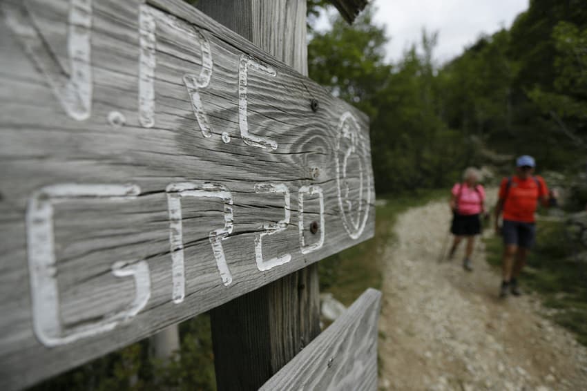
The island GR - Also reputed to be extremely difficult, the GR 20 crosses the Mediterranean island of Corsica running approximately north–south. It's approximately 180km long, but there is a whole lot of elevation gain (12,000m).
The Chemin de Stevenson - The GR 70 follows in the footsteps of the Scottish writer Robert Louis Stevenson, authors of classics including Dr Jekyll and Mr Hyde and Treasure Island plus - probably more pertinently in this context Travels with a Donkey in the Cévannes. If you like the sound of that, there are still companies in France that run 'donkey hike holidays', where you are loaned a donkey to carry your gear while undertaking a multiple-stage hike.
The trail runs through central France, covering 270km between Le Puy-en-Velay (Haute-Loire) and Alès (Gard).
Camino de Santiago
One of the world's most famous hiking routes may finish in Spain, but large portions of it are in France. Every year thousands of people complete some or all of the historic pilgrim route - some for religious reasons and others who simply love a challenging hike.
The most popular Camino de Santiago route from France goes along the GR65, or the Chemin du Puy, which starts in the Auvergne region and runs for 736km, but there are several different routes which link up to GR trails.
The route is also known in France as the Chemin de Saint-Jacques, and is marked along the way with a cockle shell icon.
You can find the complete list of GR trails here.
Comments
See Also
If you have spent any time in nature in France, you may have noticed or heard talk of the "GR" trails - like the GR 34 that wraps around Brittany or the GR 4 which goes from the Atlantic coast to the Mediterranean - these are numbered and signposted footpaths that criss-cross several countries in western Europe.
They are particularly notable in France, which is home to thousands of kilometres of GR hiking paths. You can see a map of them all here.
Many of them have romantic nicknames like the Mont Blanc trail or the excise-men's trail but they also have a GR number.
In France, the GR routes have been maintained by the French hiking federation and volunteers since 1947. They wind across the entire country: some follow historic or spiritual footpaths, while others pass through national parks and other exceptional natural sites.
A GR might take you around a mountain range (like the challenging 'GR TMB, le Tour du Mont-Blanc) or simply through fields and villages.
Origins
The GR routes were first created by Frenchman Jean Loiseau, who loved to walk and hike in the years following World War I.
After France introduced paid holidays in 1936, Loiseau became passionate about sharing his love for hiking with the rest of the country, drawing inspiration from the Appalachian Trail (completed in 1937) for its clear path markings.
READ MORE: 13 of France’s best hiking and cycling routes
According to the hiking federation website, it was in 1947 when the Comité National des Sentiers de Grande Randonnée (National Committee for Long-distance Hiking Trails) was first created, marking the start of the hiking federation.
Later that same year the first section of the GR 3 was inaugurated in Orléans, running between Dammartin-en-Goel and Orry-la-Ville.
How to follow them
Thanks to technology, there are now apps and websites devoted to helping people plan their perfect GR itinerary, including a helpful planning site run by the hiking federation.
Once you're on the trial, there are also helpful route markings.
The French GR symbol that you are going in the right direction looks like an equals sign, with the top line in white and the bottom in red.
Bouger#sport #sentier #toulouse #instasport #nature #forest #bytoulouse #visiteztoulouse #mahautegaronne #GR #hiking #instahike #instamoment #randonnee pic.twitter.com/7kMLlKV5OP
— Gourmandise SF 🧀🧀🧀 (@nadasto) April 16, 2018
When the path changes direction, a small white arrow will appear below the red line. If you are going the wrong way, you will be informed by a red and white 'X'.
Which ones are the best?
There are too many GR routes to choose from, and each of them offers something special. Many people opt to just hike a small portion of the trail, rather than the whole thing, while others take on the challenge of walking the entire path.
Here are a few standouts;
The longest GR in France - Even though the GR 34 (Sentier des Douaniers) is the longest footpath, it is also one of France's most accessible.
It stretches over 2,000km, taking you around the coastline in Brittany. It alternates from beaches and cliffs, passing through the Emerald Coast and nearby to Mont-Saint-Michel.
The shortest GR in France - The GR 92 is just 23km long, and an experienced hiker can complete it in under 10 hours. That being said, its a bit of a tricky route, located in Vaucluse and linking the towns of Apt and Sannes via the Lubéron mountain range.
The hardest GR in France - This might be a bit subjective, but many people consider the GR TMB (Mont-Blanc) to be one of the most challenging. Even though it is surrounded by magnificent scenery, it takes you on a 170km loop around Mont Blanc, with 10,000m of elevation climb. It takes most people around 7-10 days to do the whole thing.
The island GR - Also reputed to be extremely difficult, the GR 20 crosses the Mediterranean island of Corsica running approximately north–south. It's approximately 180km long, but there is a whole lot of elevation gain (12,000m).
The Chemin de Stevenson - The GR 70 follows in the footsteps of the Scottish writer Robert Louis Stevenson, authors of classics including Dr Jekyll and Mr Hyde and Treasure Island plus - probably more pertinently in this context Travels with a Donkey in the Cévannes. If you like the sound of that, there are still companies in France that run 'donkey hike holidays', where you are loaned a donkey to carry your gear while undertaking a multiple-stage hike.
The trail runs through central France, covering 270km between Le Puy-en-Velay (Haute-Loire) and Alès (Gard).
Camino de Santiago
One of the world's most famous hiking routes may finish in Spain, but large portions of it are in France. Every year thousands of people complete some or all of the historic pilgrim route - some for religious reasons and others who simply love a challenging hike.
The most popular Camino de Santiago route from France goes along the GR65, or the Chemin du Puy, which starts in the Auvergne region and runs for 736km, but there are several different routes which link up to GR trails.
The route is also known in France as the Chemin de Saint-Jacques, and is marked along the way with a cockle shell icon.
You can find the complete list of GR trails here.
Join the conversation in our comments section below. Share your own views and experience and if you have a question or suggestion for our journalists then email us at [email protected].
Please keep comments civil, constructive and on topic – and make sure to read our terms of use before getting involved.
Please log in here to leave a comment.