France urged to stay indoors on Wednesday night amid storm risk
Storm Ciaran is set to reach northwestern France on Wednesday evening bringing dangerous winds of up to 170 km/h and a risk of floods. Authorities have urged people to avoid leaving the house.
French Interior Minister, Gérald Darmanin, has called on people "across the country to not go out on Wednesday night through to Thursday" amid the threat posed by Storm Ciaran.
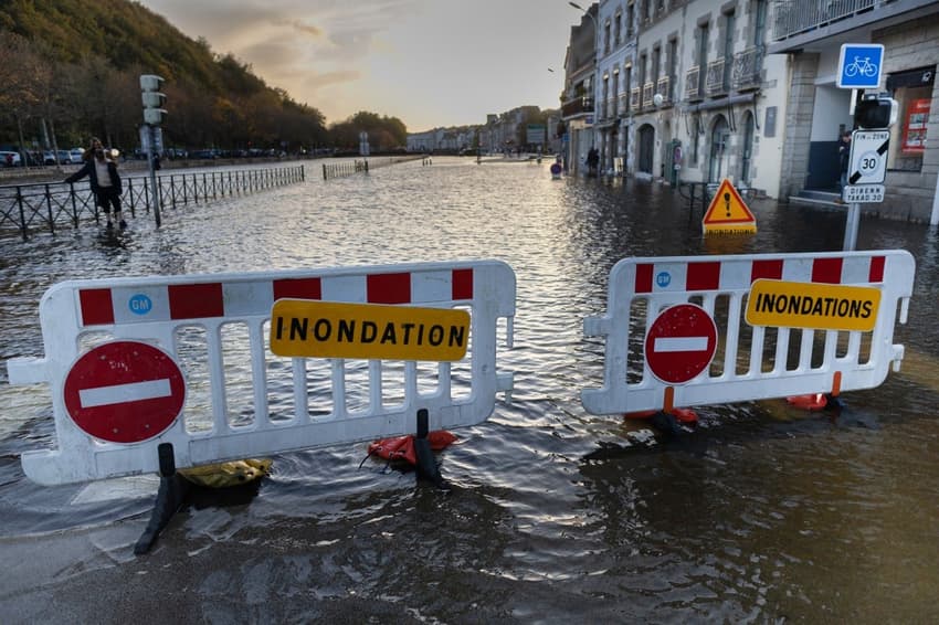
Winds of up to 170 km/h are expected along in Brittany and there is a risk of flooding along almost all of the northern and western coastline of France. Rainfall in some areas is expected to reach up to 50 mm.
Darmanin also called on the population to "stay away from the sea and other bodies of water" and to "take care of vulnerable people."
Local authorities in Brittany have also warned people to watch out for falling trees and the National Forests Authority has said to avoid walking in the forests of northwestern France until next week.
Météo France, the country's national meteorological service, has issued a red warning for the departments of Manche, Côtes d'Armor and Finistère. From midnight on Wednesday, people in these areas should exercise maximum vigilance.
17 other departments have are urged to be very vigilant in the face of the impending storm.
🔴 3 départements en Rouge
🔶 17 départements en Orange pic.twitter.com/Dlqr2YsFxR
— VigiMétéoFrance (@VigiMeteoFrance) November 1, 2023
The strongest winds are expected to last until around 10am on Thursday morning, when the 'red alert' is set to expire.
Ahead of the storm's arrival, more than 3000 firemen and four helicopters will be deployed in the areas most likely to be impacted.
While storms are a naturally recurring phenomenon, they can be made worse by climate change, according to scientists.
Flooding is likely to be exacerbated by rising ocean levels as a result of melting glaciers.
Travel disruption
Some train and ferry services have been cancelled from Wednesday evening in anticipation of adverse weather conditions.
On Thursday TER services will not run in Normandy, Brittany, the Pays-de-Loire, the Hauts-de-France and the Centre-Val de Loire on Thursday - except for the line from Paris-Bercy to Nevers. TGV services have been suspended on Thursday in the Pays de la Loire and Brittany, except for the Paris-Rennes line.
The Brest Bretagne airport will be closed from 17h on Wednesday until at least 9h30 on Thursday. Quimper airport, also in Brittany, closed early Wednesday for 24 hours.
Eurostar, expecting disruptions and slowdowns, told AFP it was recommending that passengers delay their trips planned for Thursday.
The heavy rain and very high winds are also likely to affect ferry crossings on the Channel on Wednesday evening and Thursday, operator DFDS announced on Tuesday that several cross-Channel services had been cancelled due to "adverse weather".
Anyone with a trip booked should check with their operator before travelling to the port.
Maritime authorities issued a strong warning against taking boats out to sea, or even approaching the coast "be it by car or on foot".
They also said a powerful tugboat would be deployed to help any vessels in distress.
"All we can do is to lie low and keep our fingers crossed," said Olivier Laban, president of the shellfish farming committee in the Arcachon basin in France's southwest.
Comments
See Also
French Interior Minister, Gérald Darmanin, has called on people "across the country to not go out on Wednesday night through to Thursday" amid the threat posed by Storm Ciaran.
Winds of up to 170 km/h are expected along in Brittany and there is a risk of flooding along almost all of the northern and western coastline of France. Rainfall in some areas is expected to reach up to 50 mm.
Darmanin also called on the population to "stay away from the sea and other bodies of water" and to "take care of vulnerable people."
Local authorities in Brittany have also warned people to watch out for falling trees and the National Forests Authority has said to avoid walking in the forests of northwestern France until next week.
Météo France, the country's national meteorological service, has issued a red warning for the departments of Manche, Côtes d'Armor and Finistère. From midnight on Wednesday, people in these areas should exercise maximum vigilance.
17 other departments have are urged to be very vigilant in the face of the impending storm.
🔴 3 départements en Rouge
— VigiMétéoFrance (@VigiMeteoFrance) November 1, 2023
🔶 17 départements en Orange pic.twitter.com/Dlqr2YsFxR
The strongest winds are expected to last until around 10am on Thursday morning, when the 'red alert' is set to expire.
Ahead of the storm's arrival, more than 3000 firemen and four helicopters will be deployed in the areas most likely to be impacted.
While storms are a naturally recurring phenomenon, they can be made worse by climate change, according to scientists.
Flooding is likely to be exacerbated by rising ocean levels as a result of melting glaciers.
Travel disruption
Some train and ferry services have been cancelled from Wednesday evening in anticipation of adverse weather conditions.
On Thursday TER services will not run in Normandy, Brittany, the Pays-de-Loire, the Hauts-de-France and the Centre-Val de Loire on Thursday - except for the line from Paris-Bercy to Nevers. TGV services have been suspended on Thursday in the Pays de la Loire and Brittany, except for the Paris-Rennes line.
The Brest Bretagne airport will be closed from 17h on Wednesday until at least 9h30 on Thursday. Quimper airport, also in Brittany, closed early Wednesday for 24 hours.
Eurostar, expecting disruptions and slowdowns, told AFP it was recommending that passengers delay their trips planned for Thursday.
The heavy rain and very high winds are also likely to affect ferry crossings on the Channel on Wednesday evening and Thursday, operator DFDS announced on Tuesday that several cross-Channel services had been cancelled due to "adverse weather".
Anyone with a trip booked should check with their operator before travelling to the port.
Maritime authorities issued a strong warning against taking boats out to sea, or even approaching the coast "be it by car or on foot".
They also said a powerful tugboat would be deployed to help any vessels in distress.
"All we can do is to lie low and keep our fingers crossed," said Olivier Laban, president of the shellfish farming committee in the Arcachon basin in France's southwest.
Join the conversation in our comments section below. Share your own views and experience and if you have a question or suggestion for our journalists then email us at [email protected].
Please keep comments civil, constructive and on topic – and make sure to read our terms of use before getting involved.
Please log in here to leave a comment.