How to hike or cycle the WWI 'Western Front' route in France
Running from the Belgian coastline, through France and to the Swiss border a 1,000km hiking and cycle trail follows the route of the trenches of the World War I 'western front' - and now there is a phone app aimed at helping English-speakers navigate the trail.
If you are interested in learning history on-the-ground, you might be interested in hiking or cycling some or all of the Western Front Way - a network of paths that follow the route of the WWI trenches, through the French and Belgian countryside.
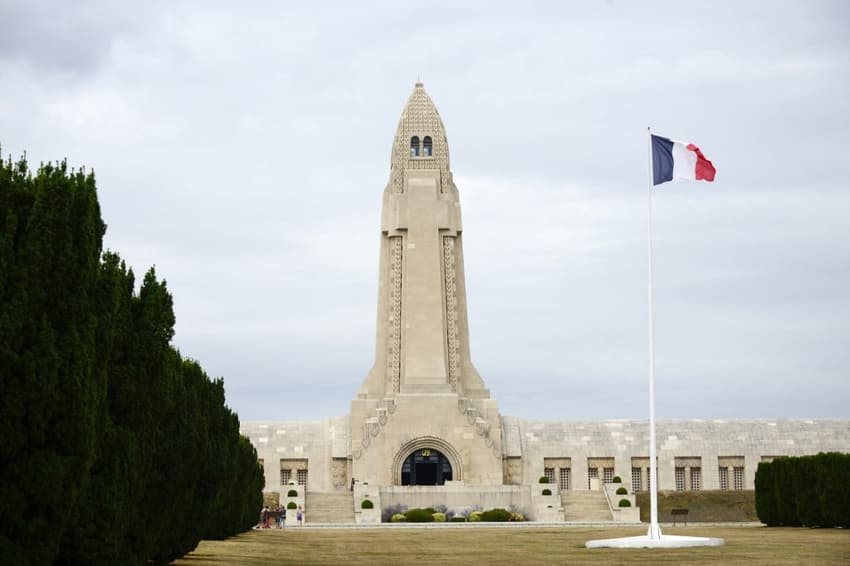
The route is 1,000km and it follows the path of the 'western front' of trenches, which by 1915 stretched all the way from Ostend in Belgium to the Swiss border and encompassed some of the most infamous battles of the war, from the Battle of the Somme to Passchendael, Verdun and the Marne.
The original idea for a path came from AD Gillespie, a soldier in the Scottish regiment the Argyll and Sutherland Highlanders, who wrote that he dreamed of "a place where nations could walk together in peace". He died shortly after writing that letter in 1915.
The route comprises a mixture of French and Belgian GR hiking paths and the Route Santiago, running through French and Belgian localities along the WWI frontlines and taking in many of the famous battlefields and memorials.
It would take approximately 41 days (when hiking 15 miles a day) to manage the whole distance, but it is accessible in smaller segments.
For cycling, the trail could be manageable in seven days, if one bikes approximately 125km per day (though the Vosges is rather mountainous and makes for a challenging cycle).
The app
French and Belgian local authorities publish information and route maps for their own sections of the path, so you can put together your own route. For example - the Meuse département, home to the Verdun battlefield, has a tourism page dedicated to hiking through WWI battlefields - you can find it here.
However, for English-speakers the app Western Front Way provides interactive maps of the whole route, plus additional historical info on the sites you pass.
READ MORE: Five French hiking spots that are accessible from Paris
If you choose to download the paid app (£19.99 per year) then it will also be curated - offering you history lessons, recommendations for where to eat and stay, navigation, and recommended stopping points.
Western Front Way has taken existing trail ways to put together two options for the route: one for cyclists and one for hikers. The total path is broken into segments, so you can go at your own pace.
The app is available for both android and iPhone users. You can download it and find more information here.
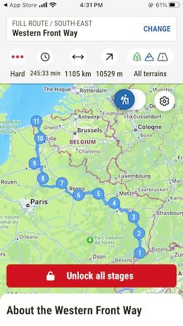
A screenshot from the Western Front Way mobile phone application, showing the trail
Comments
See Also
If you are interested in learning history on-the-ground, you might be interested in hiking or cycling some or all of the Western Front Way - a network of paths that follow the route of the WWI trenches, through the French and Belgian countryside.
The route is 1,000km and it follows the path of the 'western front' of trenches, which by 1915 stretched all the way from Ostend in Belgium to the Swiss border and encompassed some of the most infamous battles of the war, from the Battle of the Somme to Passchendael, Verdun and the Marne.
The original idea for a path came from AD Gillespie, a soldier in the Scottish regiment the Argyll and Sutherland Highlanders, who wrote that he dreamed of "a place where nations could walk together in peace". He died shortly after writing that letter in 1915.
The route comprises a mixture of French and Belgian GR hiking paths and the Route Santiago, running through French and Belgian localities along the WWI frontlines and taking in many of the famous battlefields and memorials.
It would take approximately 41 days (when hiking 15 miles a day) to manage the whole distance, but it is accessible in smaller segments.
For cycling, the trail could be manageable in seven days, if one bikes approximately 125km per day (though the Vosges is rather mountainous and makes for a challenging cycle).
The app
French and Belgian local authorities publish information and route maps for their own sections of the path, so you can put together your own route. For example - the Meuse département, home to the Verdun battlefield, has a tourism page dedicated to hiking through WWI battlefields - you can find it here.
However, for English-speakers the app Western Front Way provides interactive maps of the whole route, plus additional historical info on the sites you pass.
READ MORE: Five French hiking spots that are accessible from Paris
If you choose to download the paid app (£19.99 per year) then it will also be curated - offering you history lessons, recommendations for where to eat and stay, navigation, and recommended stopping points.
Western Front Way has taken existing trail ways to put together two options for the route: one for cyclists and one for hikers. The total path is broken into segments, so you can go at your own pace.
The app is available for both android and iPhone users. You can download it and find more information here.
Join the conversation in our comments section below. Share your own views and experience and if you have a question or suggestion for our journalists then email us at [email protected].
Please keep comments civil, constructive and on topic – and make sure to read our terms of use before getting involved.
Please log in here to leave a comment.