Weather warnings for Paris and northern France as Storm Gérard batters country
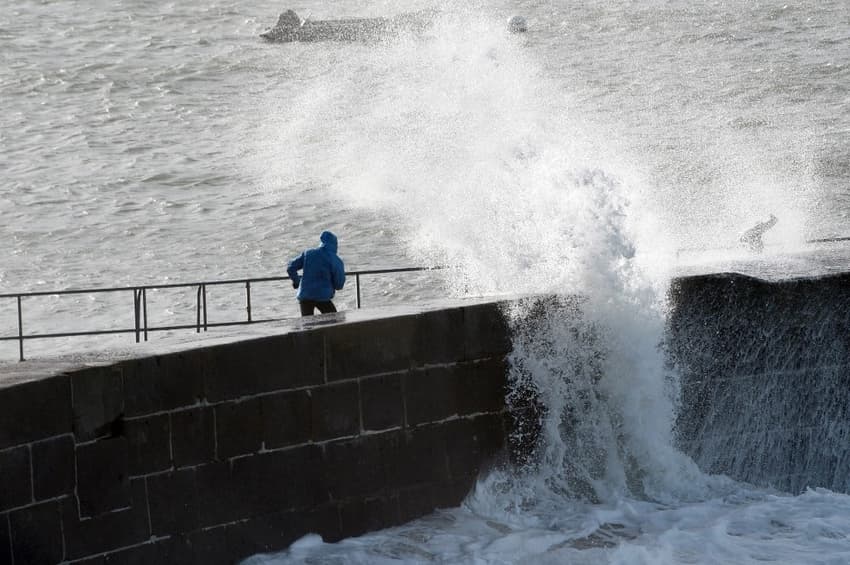
Paris and much of the north-west of France has been placed on alert for high winds, heavy rain and possible flooding as Storm Gérard batters the country.
In total 26 départements are on an orange weather alert, the majority in the north and west of the country.
Aube, Calvados, Côtes-d'Armor, Eure, Eure-et-Loir, Ille-et-Vilaine, Loire-Atlantique, Loiret, Manche, Marne, Mayenne, Orne, Paris, Sarthe, Seine-Maritime, Seine-et-Marne, Yvelines, Vendée, Yonne, Essonne, Hauts-de-Seine, Seine-Saint-Denis and Val-de-Marne are on alert for high winds, with alerts on flooding in some areas.
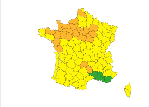
Map: Météo France
The southern départements of Cantal and Lozère are not expected to be hit by the storm, but are on alert for heavy snowfall.
Overnight on Sunday a "violent gust of wind linked to storm Gérard hit the north-western part of the country", said the service VigimétéoFrance.
Winds of up to 158km/h were recorded on the Brittany coast, while a gust of 132km/h was recorded on top of the Eiffel Tower on Sunday night.
On Monday morning, 75,000 homes were without power in western France.
The storm is expected to move east over the Paris region on Monday, before losing its intensity in the early afternoon. the weather alerts are in place until 3pm.
Meanwhile snow is forecast in the mountains - in the south of the Massif Central and the Alps from 600 to 800m, from 1,000 to 1,200m in the Pyrenees, and 500m in the Vosges and the Jura.
While this will doubtless be welcomed by the many ski resorts that were forced to close in January because of a lack of snow, authorities have issued warnings of difficult conditions to drivers in those areas.
Comments
See Also
In total 26 départements are on an orange weather alert, the majority in the north and west of the country.
Aube, Calvados, Côtes-d'Armor, Eure, Eure-et-Loir, Ille-et-Vilaine, Loire-Atlantique, Loiret, Manche, Marne, Mayenne, Orne, Paris, Sarthe, Seine-Maritime, Seine-et-Marne, Yvelines, Vendée, Yonne, Essonne, Hauts-de-Seine, Seine-Saint-Denis and Val-de-Marne are on alert for high winds, with alerts on flooding in some areas.
The southern départements of Cantal and Lozère are not expected to be hit by the storm, but are on alert for heavy snowfall.
Overnight on Sunday a "violent gust of wind linked to storm Gérard hit the north-western part of the country", said the service VigimétéoFrance.
Winds of up to 158km/h were recorded on the Brittany coast, while a gust of 132km/h was recorded on top of the Eiffel Tower on Sunday night.
On Monday morning, 75,000 homes were without power in western France.
The storm is expected to move east over the Paris region on Monday, before losing its intensity in the early afternoon. the weather alerts are in place until 3pm.
Meanwhile snow is forecast in the mountains - in the south of the Massif Central and the Alps from 600 to 800m, from 1,000 to 1,200m in the Pyrenees, and 500m in the Vosges and the Jura.
While this will doubtless be welcomed by the many ski resorts that were forced to close in January because of a lack of snow, authorities have issued warnings of difficult conditions to drivers in those areas.
Join the conversation in our comments section below. Share your own views and experience and if you have a question or suggestion for our journalists then email us at [email protected].
Please keep comments civil, constructive and on topic – and make sure to read our terms of use before getting involved.
Please log in here to leave a comment.