A major housing project in the Normandy town of Caen has been scrapped because of fears of rising sea level, it has been revealed.
And this is not the only project affected as France and its long coastline are predicted to be strongly affected by sea levels rising.
The UN's Intergovernmental Panel on Climate Change (IPCC) projects a "likely" sea level rise of 40 to 80 centimetres by 2100.
In the worst case scenario - should humanity fail to take the necessary steps to reduce greenhouse gas emissions - experts warn the increase could be closer to 1.02 metres.
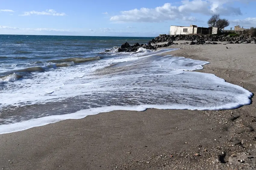
If oceans do rise by one metre, many parts of France would be severely impacted.
The American research institute Climate Central has attempted to simulate what the world would look like with a one-metre rise in sea levels, highlighting in red the land most at-risk to be underwater.
You can also see their simulation for France's coastline in 2050.
From the coastal area near Montpellier (Les Saintes-Maries-de-la-Mer) becoming a peninsula to many of La Vendée's beautiful beaches under water, here is how the face of France could change as a result of one metre of sea level rise:
Northern France and Normandy
One metre of sea level rise would particularly impact the area from Calais to Dunkirk - a distance of almost 45 kilometres - as shown in the map below. Higher tides would cover areas up to 15-20 km inland, as well.
In Normandy, the collapse of cliffs, like those in Étretat has been a sign of rising waters, Denis Lacroix, a representative from the French Research Institute for Exploitation of the Sea told BFMTV in 2022.
He added that while coastal erosion is one sign, the sea will not "rise like a bathtub," and that first there will be "extreme weather events."
Another part of the English Channel coastline, the coastline south of the chic coastal town of La Touquet to Ault stands to be eroded by water, with some higher altitude sections spared, though destined - in a scenario of one metre sea level rise - to become islands.
That area includes the low lying Baie de Somme, as well as stunning villages such as Saint-Valery sur Somme and La Crotoy.
Parts of Normandy that may also be impacted are the flood planes along the mouth of the Seine river near La Havre, and the national wetland park made up of the Cotentin & Bessin marshes, which is home to much wildlife and a diverse bird population on the Cotentin peninsular.
READ MORE: Rising sea levels threaten Normandy's historic D-Day beaches
Similarly, the historic D-Day beaches are already noticing rising tides, and the area around Caen and the Orne river estuary, would be affected. Construction plans have already been disrupted due to expected sea level rise.
In 2024, a development project that would have transformed a strip of industrial wasteland into offices and 2,300 homes - located between the River Orne and the canal linking Caen to the sea - had to be shelved.
The head of the organisation running the 'Nouveau Bassin' project, Thibaud Tiercelet, told AFP that "if the sea rises by one metre, it will flood here every week."
In Loire-Atlantique
Much of the mouth of the Loire river near Nantes will be under water amid these climate forecasts. Riverside parts of the city of Nantes will be impacted, though based on current projections, the city as a whole would mostly remain above water.
In La Vendée
The map shows significant portions of red in the area north of La Rochelle, particularly the regional Park of the Marais Poitevin - known for its canals and wetlands.
Some of La Vendée's stunning beaches, like Plage des Becs could be underwater in 2100, if waters go up by one metre.
According to Lacroix, sea level rise is "an accelerating phenomenon," as evidenced by the fact that "in the last century, the rise in sea level was two milimetres per year, but over the last twenty years it has been four milimetres."
In Gironde and Charente-Maritime
Most of the coastline north of Bordeaux to Rochefort could be underwater by 2100.
One symbol of coastal erosion in Gironde is the building Le Signal, in Soulac-sur-Mer. When it was built in 1967, it was 200 metres from the shore, and in 2022 it was only about ten meters from the water.
« Le Signal » / Soulac-sur-Mer#Érosion #Littoral #Médoc #Gironde pic.twitter.com/7Y3pw5DUM3
— Jean-Philippe Vriet (@JeanPhilipVriet) January 1, 2021
There is particular concern for the Lacanau area in Gironde, which has a population density on its coasts which is "2.5 times higher than the national average," according to France's ministry of environment. In the coming years, inhabitants in this area may have to be evacuated due to sea level rise.
On the Mediterranean
Finally, along the Mediterranean, the coastline of the Hérault département will be particularly affected. This area is mostly located near Montpellier, as shown below:
There is considerable risk for the Saintes-Maries-de-la-Mer to become a peninsula over time.
France's Ministry of Ecology has produced a map which shows the parts of the country at risk of rising sea levels, but also forest fires and flooding.
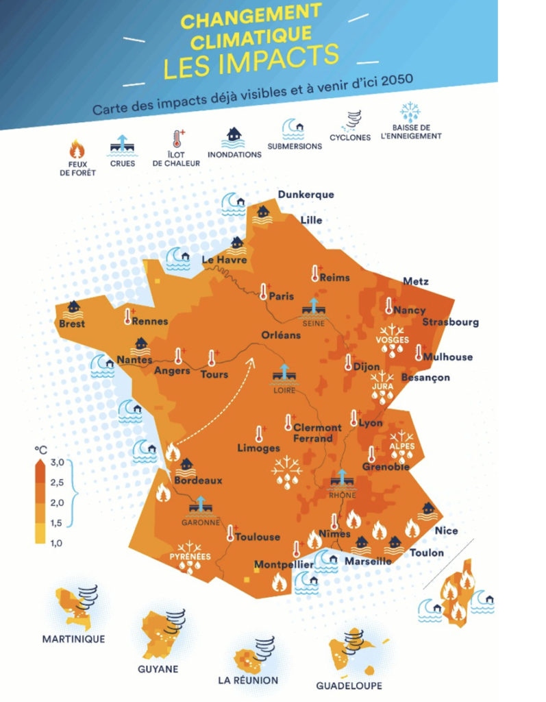
As of 2024, over 16.8 million people in mainland France already lived in areas at risk of flooding, according to the French Ministry of Ecological Transition.
The French news outlet, Reporterre, reported that by 2028, more than a thousand buildings could be directly impacted by sea level rise, and by 2050 more than 5,000 homes and 1,400 businesses would be, leading to losses of €1.2 billion.
Comments