Violent weather returns to France with 15 storm warnings
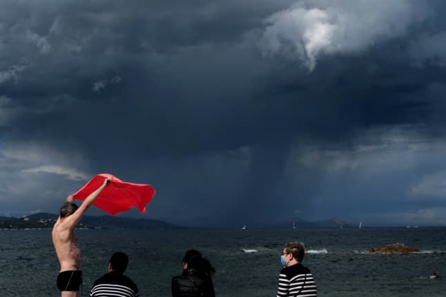
After a brief respite with sunshine across the country, 15 areas were placed on "orange" alert for storms on Friday, mainly in central and western France.
A first storm was predicted to hit Brittany on Monday morning, beginning in the southern part of the region before moving north in the afternoon. A second storm was forecast for western Brittany in the afternoon, before moving on to the Manche department in Normandy in the evening.
🔶 17 dpts en #vigilanceOrange
Restez informés sur https://t.co/rJ24zzmmy4 pic.twitter.com/homNrnRs8S
— VigiMétéoFrance (@VigiMeteoFrance) July 23, 2021
The orange alert from Météo France is the second highest alert level, which in this case means lightning, hailstorms, heavy rain, and winds of up to 90 km/h.
"A third period of violent storms is expected in the evening in Limousin, Auvergne, and Burgundy," according to the forecaster. The central regions were warned to expect winds of up to 100 km/h, heavy rain, and "fairly large hailstones".
In addition to the 15 départements where storms were forecast, the Aisne and Oise départements remained on orange alert for floods and rising water levels.
Those areas have been particularly hard hit by the volatile weather seen in France this summer. Following extreme flooding, mudslides and damage to property at the end of June, with a month's worth of rain falling in a single night, the state officially recognised the storms as a natural disaster in 29 communes in Oise. A further 22 communes received the same classification earlier this week.
Orage d'une intensité incroyable et stationnaire sur la ville de #Beauvais qui à subi de graves inondations localement avec + de 100mm de plus en mm 1 heure hier soir. #meteo60 #orages #inondations #crues #violent #picardie #orage
Vidéo Samir pic.twitter.com/usPJNHOIe4
— Chasseur d'orages Lorrain - Guillaume Hobam 🌪️⚡ (@Chasseur_Orages) June 22, 2021
This week has seen warm temperatures across France, rising above 35C in the south-west, and above 30C in Brittany.
"In Brest, it's unprecedented to have three consecutive days at more than 30C in the month of July," Météo France said.
Bad news for those who were rejoicing that summer was finally here: more storms are forecast for the weekend, and the unpredictable weather is set to continue into next week, according to Météo France.
"The week has in store rain showers alternated with periods of respite. The middle of the week will however be reasonably sunny in general. The Mediterranean regions will retain mostly warm and dry weather."
Comments (1)
See Also
A first storm was predicted to hit Brittany on Monday morning, beginning in the southern part of the region before moving north in the afternoon. A second storm was forecast for western Brittany in the afternoon, before moving on to the Manche department in Normandy in the evening.
🔶 17 dpts en #vigilanceOrange
— VigiMétéoFrance (@VigiMeteoFrance) July 23, 2021
Restez informés sur https://t.co/rJ24zzmmy4 pic.twitter.com/homNrnRs8S
The orange alert from Météo France is the second highest alert level, which in this case means lightning, hailstorms, heavy rain, and winds of up to 90 km/h.
"A third period of violent storms is expected in the evening in Limousin, Auvergne, and Burgundy," according to the forecaster. The central regions were warned to expect winds of up to 100 km/h, heavy rain, and "fairly large hailstones".
In addition to the 15 départements where storms were forecast, the Aisne and Oise départements remained on orange alert for floods and rising water levels.
Those areas have been particularly hard hit by the volatile weather seen in France this summer. Following extreme flooding, mudslides and damage to property at the end of June, with a month's worth of rain falling in a single night, the state officially recognised the storms as a natural disaster in 29 communes in Oise. A further 22 communes received the same classification earlier this week.
Orage d'une intensité incroyable et stationnaire sur la ville de #Beauvais qui à subi de graves inondations localement avec + de 100mm de plus en mm 1 heure hier soir. #meteo60 #orages #inondations #crues #violent #picardie #orage
— Chasseur d'orages Lorrain - Guillaume Hobam 🌪️⚡ (@Chasseur_Orages) June 22, 2021
Vidéo Samir pic.twitter.com/usPJNHOIe4
This week has seen warm temperatures across France, rising above 35C in the south-west, and above 30C in Brittany.
"In Brest, it's unprecedented to have three consecutive days at more than 30C in the month of July," Météo France said.
Bad news for those who were rejoicing that summer was finally here: more storms are forecast for the weekend, and the unpredictable weather is set to continue into next week, according to Météo France.
"The week has in store rain showers alternated with periods of respite. The middle of the week will however be reasonably sunny in general. The Mediterranean regions will retain mostly warm and dry weather."
Join the conversation in our comments section below. Share your own views and experience and if you have a question or suggestion for our journalists then email us at [email protected].
Please keep comments civil, constructive and on topic – and make sure to read our terms of use before getting involved.
Please log in here to leave a comment.