MAP: Where in France are Covid-19 cases rising and which areas are low risk?
Covid-19 continues to spread at increased speed across the French territory, and public health authorities now have 88 mainland départements on their risk list. Here's look at what that means.
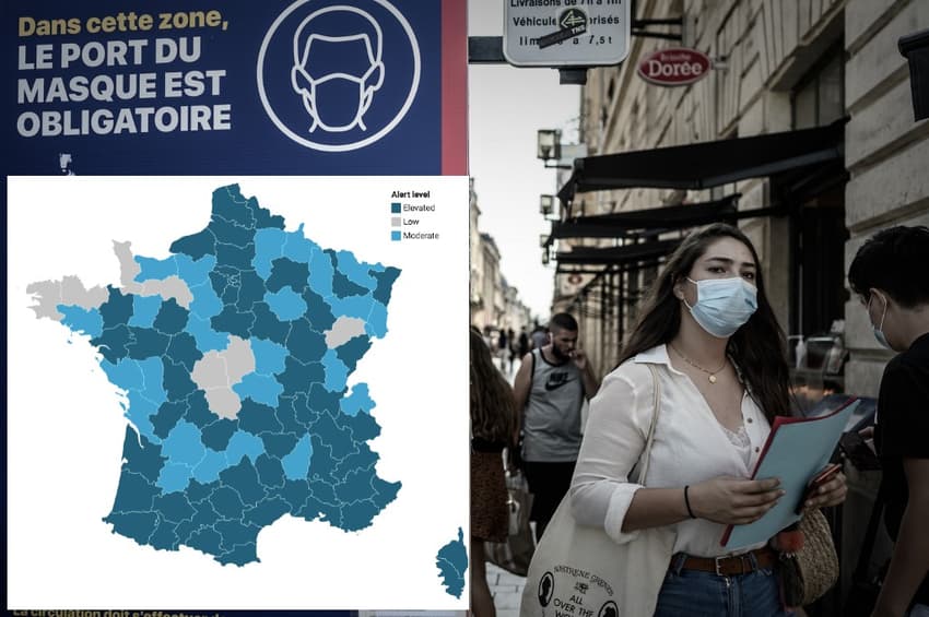
Of France's 96 mainland départements, 88 were considered at a "moderate" or "elevated" risk for Covid-19 by Santé Publique France in their latest update on October 1st.
Mainland France now has just 8 départements which are considered low risk.
A département's level is decided by Santé Publique France in consultation with the regional health authority. A range of factors are taken into account including the number of new cases, the number of clusters, the R rate, hospital admissions and the number of patients in intensive care.
Elevated risk zones
The dark blue areas were those at elevated risk, which generally indicates a high level spread of more than 50 new cases confirmed per 100,000 inhabitants over the preceding seven days.
Moderate risk zones
The lighter blue zones on the map were those at moderate risk.
Santé Publique France labels a département at 'moderate' risk generally when health authorities have registered between 10 and 50 new coronavirus cases per 100,000 inhabitants in the last seven days.
IN NUMBERS: How fast are France's Covid-19 rates increasing?
Low risk zones
These are areas with fewer than 10 cases per 100,000 over the last 7 days and where there is little pressure on the areas hospitals from Covid-19 patients. As the map shows, there are not many of these "low risk" area left in France.
Infection rates over the last seven days
The map below from Santé Publique France also gives an idea of where cases are rising more rapidly than others. The ùap is based on the infection or incidence rates in different départements over the last seven days. The areas coloured dark blue are those with the highest infection rates.
The map is interactive so you can zoom in and hover your mouse over each département to find the infection rate.
What about red zones?
You might have also seen the French government's latest map, which assigns all areas in France a shade of red.
This rating is based on both case numbers and the pressure on local hospitals and - crucially - determines what restrictions are in place on daily life.
Areas show in pink have a lower level of restrictions than the red areas and dark red - the 'maximum alert zones' have the most restrictions of all.
So far only two areas - the metropole ares of Marseille and Paris - have been put on maximum risk which involves the closure of all bars, gyms, leisure centres and swilling pools and a ban on gatherings of more than 10 people.
Find out what your area is coloured on the restrictions map HERE.
Comments (2)
See Also
Of France's 96 mainland départements, 88 were considered at a "moderate" or "elevated" risk for Covid-19 by Santé Publique France in their latest update on October 1st.
Mainland France now has just 8 départements which are considered low risk.
Elevated risk zones
The dark blue areas were those at elevated risk, which generally indicates a high level spread of more than 50 new cases confirmed per 100,000 inhabitants over the preceding seven days.
Moderate risk zones
The lighter blue zones on the map were those at moderate risk.
Santé Publique France labels a département at 'moderate' risk generally when health authorities have registered between 10 and 50 new coronavirus cases per 100,000 inhabitants in the last seven days.
IN NUMBERS: How fast are France's Covid-19 rates increasing?
Low risk zones
These are areas with fewer than 10 cases per 100,000 over the last 7 days and where there is little pressure on the areas hospitals from Covid-19 patients. As the map shows, there are not many of these "low risk" area left in France.
Infection rates over the last seven days
The map below from Santé Publique France also gives an idea of where cases are rising more rapidly than others. The ùap is based on the infection or incidence rates in different départements over the last seven days. The areas coloured dark blue are those with the highest infection rates.
The map is interactive so you can zoom in and hover your mouse over each département to find the infection rate.
You might have also seen the French government's latest map, which assigns all areas in France a shade of red.
This rating is based on both case numbers and the pressure on local hospitals and - crucially - determines what restrictions are in place on daily life.
Areas show in pink have a lower level of restrictions than the red areas and dark red - the 'maximum alert zones' have the most restrictions of all.
So far only two areas - the metropole ares of Marseille and Paris - have been put on maximum risk which involves the closure of all bars, gyms, leisure centres and swilling pools and a ban on gatherings of more than 10 people.
Find out what your area is coloured on the restrictions map HERE.
Join the conversation in our comments section below. Share your own views and experience and if you have a question or suggestion for our journalists then email us at [email protected].
Please keep comments civil, constructive and on topic – and make sure to read our terms of use before getting involved.
Please log in here to leave a comment.