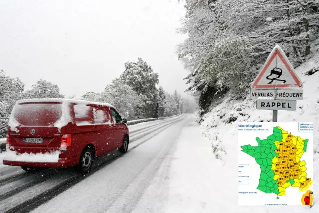
A total of 28 departments of central France have been placed on orange alert -- the second highest weather warning -- for snow and ice, according to France's national weather agency Meteo France, while storm warnings are in place in other parts of the south.
Corsica has been placed on red alert for high winds with gusts of up to 160km/h forecast. Residents there are advised not to travel by car and stay indoors in a safe place.
This was the scene in Corsica on Monday afternoon.
The departments placed on alert for snow and ice are Ain, Allier, Ardèche, Ardennes, Aube, Côte-d'Or, Drôme, Isère, Marne, Haute-Marne, Nièvre, Rhône, Saône-et-Loire and Yonne.
Creuse, Puy-de-Dome, Loire, Correze, Cantal, Haute-Loire, Lozere, Aveyron, Tarn also remain on orange alert for ice and snow.
Meanwhile Var and Alpes-Maritimes have been placed on orange alert for storms and floods while Haute-Corse and Corse-du-Sud are both on red alert for storms, flooding and high winds.
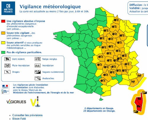
Map: Meteo France
These storms may be accompanied by hail, strong gusts of wind and heavy rainfall, according to Meteo France, with the possibility of rainfall in the region of 70/100 mm in the Var, Alpes-Maritimes and Corsica.
Gusts of wind reaching up to 100 to 130 km / h are expected to hit the northern half of Corsica before moving across the island.
"This level of wind is unusual for Corsica," said Météo France, adding that these high winds could lead to a rise in the sea level leading to flooding at vulnerable points on the coast with the city of Bastia particularly at risk.
La neige a fait son retour ce week-end en #DrômeArdèche https://t.co/ICYuvlIUFx pic.twitter.com/OYrRnVoV39
— France Bleu Drôme Ardèche (@francebleuDA) October 29, 2018
Orange alert indicates that people in these areas should be vigilant due to the risk of dangerous weather.
The alerts were put in place on Monday at 6 am and are expected to last until at least Tuesday at 6 am.
In the Massif Central in central France there had already been snow above 600 to 800 metres overnight from Sunday to Monday.
The weather agency has predicted that on Monday the snow will first hit the Haute-Loire and Lozère in the morning before moving to the Loire in the late morning and early afternoon, as well as the Puy-de-Dome, Cantal and Aveyron, lasting until Tuesday morning.
Welcome winter ?❄️☃️ #welcomewinter #snow #neige #surprise #lucinges #hautesavoie #france pic.twitter.com/Bp2qQiQihO
— Nicolas (@Myrostates) October 28, 2018
By Tuesday morning, we can expect "snow of 15 to 30 cm (locally 50 cm) above 800 to 1000 metres and at least 5 to 10 cm above 500 metres, or even lower".
En plus des fortes pluies dans le Sud-Est, attention aux chutes de #neige parfois abondantes lundi en journée et soirée :
— VigiMétéoFrance (@VigiMeteoFrance) October 28, 2018
- à très basse altitude au voisinage du Massif central et du Centre-Est (quantités peu communes en octobre)
- au-dessus de 2500m sur les Alpes frontalières pic.twitter.com/kv3e4Pcc56
Comments