Heatwave to return to France with temperatures forecast to hit 40C
The Local France - [email protected]
Published: 30 Jul, 2018 CET.
Updated: Mon 30 Jul 2018 17:03 CET
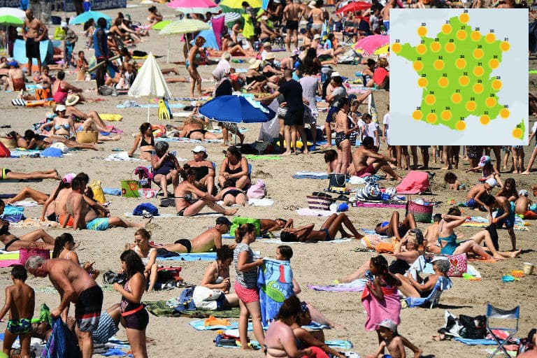
After enjoying a weekend of respite from the sweltering sun, France is set for a new heatwave this week, with forecasters predicting temperatures will rise to a whopping 40C in the south.
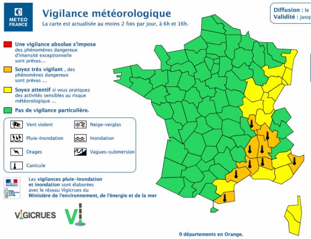
The sun and heat are returning to France this week, with nine departments already placed on orange alert -- the second highest warning -- for heatwaves by the country's national weather agency Meteo France.
The departments concerned are Ardèche, Drôme, Pyrénées-Orientales, Rhône, Alpes-Maritimes, Gard, Hérault, Isère and Vaucluse.
People in these areas are advised to be very vigilant due to the risk of dangerous weather. The alerts were updated at 4 pm on Monday and are set to remain in place until at least 4 pm on Tuesday.
READ ALSO:
-
How to keep cool during France's heatwave (especially at work)
-
How to make the most of Paris in the summer heat
 Weather map: Meteo France
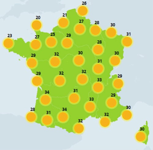
The mercury is set to reach a scorching 36C near the town of Montélimar in the Drome department on Monday afternoon.
But these aren't the only places where people in France will be roasting.
As of Monday afternoon, temperatures across most of the country are set to exceed 30C, with the city of Grenoble in the French Alps set to reach 35C.
READ ALSO:
Weather map: Meteo France
The mercury is set to reach a scorching 36C near the town of Montélimar in the Drome department on Monday afternoon.
But these aren't the only places where people in France will be roasting.
As of Monday afternoon, temperatures across most of the country are set to exceed 30C, with the city of Grenoble in the French Alps set to reach 35C.
READ ALSO:
-
Weather forecast: What's on the horizon for France this summer?
-
The best and worst things about France in the summer
 Weather forecast for Thursday 2 pm - 8 pm. Map: Meteo France
And from Wednesday things are set to get even hotter, with "anticyclonic conditions" -- a weather phenomenon that sees a large-scale circulation of winds around a central region of high atmospheric pressure which can lead to clear skies and cooler, drier air -- meaning that the weather will be very dry.
This will be particularly true in Normandy in the north east and the heat will intensify as the week progresses, especially in the Rhone Valley.
Temperatures are expected to reach between 37C and 39C in the south east, especially near Marseille and during the week, temperatures could even rise to 40C on the Mediterranean coast.
READ ALSO:
Weather forecast for Thursday 2 pm - 8 pm. Map: Meteo France
And from Wednesday things are set to get even hotter, with "anticyclonic conditions" -- a weather phenomenon that sees a large-scale circulation of winds around a central region of high atmospheric pressure which can lead to clear skies and cooler, drier air -- meaning that the weather will be very dry.
This will be particularly true in Normandy in the north east and the heat will intensify as the week progresses, especially in the Rhone Valley.
Temperatures are expected to reach between 37C and 39C in the south east, especially near Marseille and during the week, temperatures could even rise to 40C on the Mediterranean coast.
READ ALSO:
-
Can people go topless in French towns in the summer?
-
The areas of France most at risk from raging wildfires (and how to avoid them)
 Photo: AFP
By the end of the week, sunshine will be widespread across the country, with the mercury set to rise to 35C in the northern half of the country.
French weather site Meteo Villes is predicting a heatwave to take hold on Thursday or Friday and last until the following Tuesday.
France has already had its fair share of hot weather so far this summer, with the month of July breaking weather records as the hottest July on record after 2006 and 1983.
Photo: AFP
By the end of the week, sunshine will be widespread across the country, with the mercury set to rise to 35C in the northern half of the country.
French weather site Meteo Villes is predicting a heatwave to take hold on Thursday or Friday and last until the following Tuesday.
France has already had its fair share of hot weather so far this summer, with the month of July breaking weather records as the hottest July on record after 2006 and 1983.
Une #canicule se profile à partir de jeudi 2 ou vendredi 3 août et se poursuivra jusqu'au mardi 7 août avec des pointes à plus de 40°C dans le sud de la #France. (modèle GFS via @wxcharts) pic.twitter.com/1vHSILuHRb
— Météo Villes (@Meteovilles) July 30, 2018
Temperatures in July in France averaged two to four degrees above seasonal norms.
Last week 18 departments were placed on alert for heatwaves and in Paris roasting commuters resorted to recording the stifling temperatures on one of the city's busiest rail lines.
Comments
See Also
The sun and heat are returning to France this week, with nine departments already placed on orange alert -- the second highest warning -- for heatwaves by the country's national weather agency Meteo France.
The departments concerned are Ardèche, Drôme, Pyrénées-Orientales, Rhône, Alpes-Maritimes, Gard, Hérault, Isère and Vaucluse.
People in these areas are advised to be very vigilant due to the risk of dangerous weather. The alerts were updated at 4 pm on Monday and are set to remain in place until at least 4 pm on Tuesday.
READ ALSO:
- How to keep cool during France's heatwave (especially at work)
- How to make the most of Paris in the summer heat
Weather map: Meteo France
The mercury is set to reach a scorching 36C near the town of Montélimar in the Drome department on Monday afternoon.
But these aren't the only places where people in France will be roasting.
As of Monday afternoon, temperatures across most of the country are set to exceed 30C, with the city of Grenoble in the French Alps set to reach 35C.
READ ALSO:
- Weather forecast: What's on the horizon for France this summer?
- The best and worst things about France in the summer
Weather forecast for Thursday 2 pm - 8 pm. Map: Meteo France
And from Wednesday things are set to get even hotter, with "anticyclonic conditions" -- a weather phenomenon that sees a large-scale circulation of winds around a central region of high atmospheric pressure which can lead to clear skies and cooler, drier air -- meaning that the weather will be very dry.
This will be particularly true in Normandy in the north east and the heat will intensify as the week progresses, especially in the Rhone Valley.
Temperatures are expected to reach between 37C and 39C in the south east, especially near Marseille and during the week, temperatures could even rise to 40C on the Mediterranean coast.
READ ALSO:
- Can people go topless in French towns in the summer?
- The areas of France most at risk from raging wildfires (and how to avoid them)
Photo: AFP
By the end of the week, sunshine will be widespread across the country, with the mercury set to rise to 35C in the northern half of the country.
French weather site Meteo Villes is predicting a heatwave to take hold on Thursday or Friday and last until the following Tuesday.
France has already had its fair share of hot weather so far this summer, with the month of July breaking weather records as the hottest July on record after 2006 and 1983.
Une #canicule se profile à partir de jeudi 2 ou vendredi 3 août et se poursuivra jusqu'au mardi 7 août avec des pointes à plus de 40°C dans le sud de la #France. (modèle GFS via @wxcharts) pic.twitter.com/1vHSILuHRb
— Météo Villes (@Meteovilles) July 30, 2018
Temperatures in July in France averaged two to four degrees above seasonal norms.
Last week 18 departments were placed on alert for heatwaves and in Paris roasting commuters resorted to recording the stifling temperatures on one of the city's busiest rail lines.
Join the conversation in our comments section below. Share your own views and experience and if you have a question or suggestion for our journalists then email us at [email protected].
Please keep comments civil, constructive and on topic – and make sure to read our terms of use before getting involved.
Please log in here to leave a comment.