French Alps on red alert as avalanche threat reaches 'exceptional' level
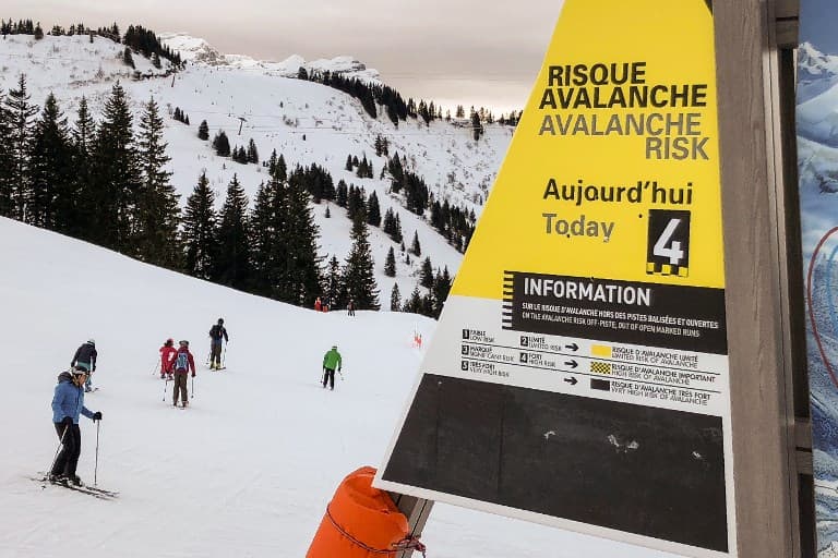
The Savoie region of the French Alps was placed on red alert for avalanches on Monday after heavy snowfall had raised the danger level to "exceptional" - which reportedly only happens around once every 30 years.
The country's weather agency Météo France placed the department of Savoie on red alert - the highest warning level - on Monday afternoon due to the heightened risk of avalanches caused by heavy snow.
The agency described the danger as of "exceptional intensity" and said numerous avalanches were expected on Monday evening.
More than 1,800 of these avalanches could take unusual trajectories and may hit roads and villages, the agency said.
Meanwhile the Hautes-Alpes department is on orange alert (one level below red) for avalanches and the Alpes-Maritimes is on orange alert for avalanches and storms.
The public are advised to avoid high roads in the area and to heed the safety advice in ski resorts.
Risque d'#avalanche maximal sur les #Alpes frontalières #VigilanceOrange
?Bonneval-sur-Arc en Savoie (2720 m) où il est tombé 90 cm de #neige depuis hier.
Restez informés : https://t.co/3PMCknwiMZ pic.twitter.com/l2oxpLWOaY
— Météo-France (@meteofrance) January 8, 2018
The heightened danger has been caused by heavy snow in recent days and more is forecast to fall between Monday afternoon and Tuesday morning.
The mountains most affected are the massifs de Haute-Maurienne and Haute-Tarentaise, which includes the ski resorts Bonneval and Bessans and Tignes and Val D'Isere.
Various roads have been blocked in the region with villages cut off.
Le département de la #Savoie a été placé ce lundi 8 janvier en fin d'après-midi en vigilance rouge #avalanches. Météo France parle d'une situation exceptionnelle. De nombreuses routes sont coupées principalement en #HauteMaurienne et #HauteTarentaise.
➡ https://t.co/A4Y2wOYnMx pic.twitter.com/sleUqPiOV6
— France 3 Alpes (@f3Alpes) January 8, 2018
Photo de Val d'Isère cet après-midi vers 15h30. Il est encore attendu 60 à 80 cm d'ici la fin de l'épisode et 80 à 100 cm sur la Haute-Maurienne. #Savoie #avalanches. Photo Météo Tarentaise : https://t.co/VdZajEiuIP pic.twitter.com/Eq9ZIm1VJA
— Keraunos (@KeraunosObs) January 8, 2018
The avalanche risk is expected to recede on Tuesday late morning.
Comments
See Also
The country's weather agency Météo France placed the department of Savoie on red alert - the highest warning level - on Monday afternoon due to the heightened risk of avalanches caused by heavy snow.
The agency described the danger as of "exceptional intensity" and said numerous avalanches were expected on Monday evening.
More than 1,800 of these avalanches could take unusual trajectories and may hit roads and villages, the agency said.
Meanwhile the Hautes-Alpes department is on orange alert (one level below red) for avalanches and the Alpes-Maritimes is on orange alert for avalanches and storms.
The public are advised to avoid high roads in the area and to heed the safety advice in ski resorts.
Risque d'#avalanche maximal sur les #Alpes frontalières #VigilanceOrange
— Météo-France (@meteofrance) January 8, 2018
?Bonneval-sur-Arc en Savoie (2720 m) où il est tombé 90 cm de #neige depuis hier.
Restez informés : https://t.co/3PMCknwiMZ pic.twitter.com/l2oxpLWOaY
The heightened danger has been caused by heavy snow in recent days and more is forecast to fall between Monday afternoon and Tuesday morning.
The mountains most affected are the massifs de Haute-Maurienne and Haute-Tarentaise, which includes the ski resorts Bonneval and Bessans and Tignes and Val D'Isere.
Various roads have been blocked in the region with villages cut off.
Le département de la #Savoie a été placé ce lundi 8 janvier en fin d'après-midi en vigilance rouge #avalanches. Météo France parle d'une situation exceptionnelle. De nombreuses routes sont coupées principalement en #HauteMaurienne et #HauteTarentaise.
— France 3 Alpes (@f3Alpes) January 8, 2018
➡ https://t.co/A4Y2wOYnMx pic.twitter.com/sleUqPiOV6
Photo de Val d'Isère cet après-midi vers 15h30. Il est encore attendu 60 à 80 cm d'ici la fin de l'épisode et 80 à 100 cm sur la Haute-Maurienne. #Savoie #avalanches. Photo Météo Tarentaise : https://t.co/VdZajEiuIP pic.twitter.com/Eq9ZIm1VJA
— Keraunos (@KeraunosObs) January 8, 2018
The avalanche risk is expected to recede on Tuesday late morning.
Join the conversation in our comments section below. Share your own views and experience and if you have a question or suggestion for our journalists then email us at [email protected].
Please keep comments civil, constructive and on topic – and make sure to read our terms of use before getting involved.
Please log in here to leave a comment.