Brittany and Normandy on alert as violent storms roll in
Oliver Gee - [email protected]
Published: 3 Feb, 2017 CET.
Updated: Fri 3 Feb 2017 09:21 CET
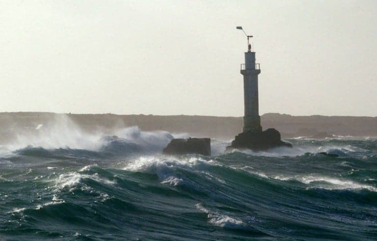
North western France is on alert as storm Kurt lashes the region, causing massive waves and flood risks.
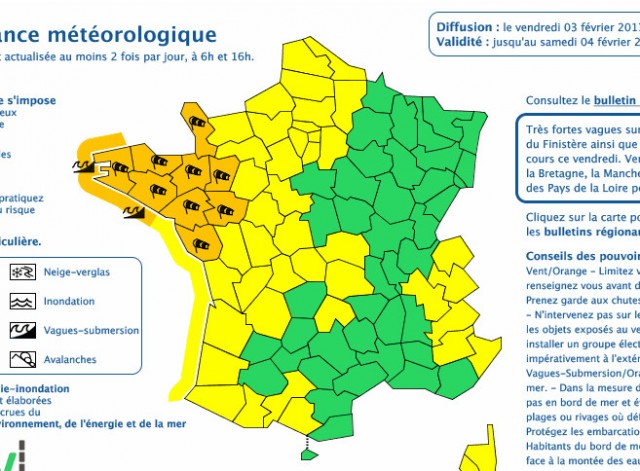
National weather agency Météo France has put nine departments on orange alert for strong winds and flood risks.
Orange is the second highest warning level on the agency's system.
All the departments on alert are in the north western corner of France: Ille-et-Vilaine, Loire-Atlantique, Maine-et-Loire, Mayenne, Vendée, Côtes-d'Armor, Finistère, Manche, and Morbihan.
Météo France said that gale force winds would bring more "very strong waves" to the Brittany coastline, particularly from the south.
The storm, which hit on Thursday evening, has already caused wave peaks of up to 12 metres.
#tempête #Kurt vue par ARPEGE/@meteofrance, frappant ce vendredi 3/02 le NW-#France, suivie de #Leiv samedi plus au sud (cartes @infoclimat) pic.twitter.com/K5yWkvHhzY
— Etienne Kapikian (@EKMeteo) February 2, 2017
Residents have been warned of the risks of "marine submersion", where large waves and declining water levels can lead to flooding in coastal areas.
"The marine submersion could cause severe and rapid flooding, and the waves could damage coastal infrastructure," the agency said.
VIDEO - Les premières images de la tempête #Kurt en Francehttps://t.co/AaWraTw2cb pic.twitter.com/xfYLMy1mLB
— BFMTV (@BFMTV) February 3, 2017
The agency urged people to keep away from the coastline and out of the water at all costs.
It added that Friday would see winds of up to 130 km/hr.
"The wind may disrupt human activities and significant damage is expected," Météo France said, adding that people should keep off roofs and be vigilant about the risks of falling trees.
Comments
See Also
National weather agency Météo France has put nine departments on orange alert for strong winds and flood risks.
Orange is the second highest warning level on the agency's system.
All the departments on alert are in the north western corner of France: Ille-et-Vilaine, Loire-Atlantique, Maine-et-Loire, Mayenne, Vendée, Côtes-d'Armor, Finistère, Manche, and Morbihan.
Météo France said that gale force winds would bring more "very strong waves" to the Brittany coastline, particularly from the south.
The storm, which hit on Thursday evening, has already caused wave peaks of up to 12 metres.
#tempête #Kurt vue par ARPEGE/@meteofrance, frappant ce vendredi 3/02 le NW-#France, suivie de #Leiv samedi plus au sud (cartes @infoclimat) pic.twitter.com/K5yWkvHhzY
— Etienne Kapikian (@EKMeteo) February 2, 2017
Residents have been warned of the risks of "marine submersion", where large waves and declining water levels can lead to flooding in coastal areas.
"The marine submersion could cause severe and rapid flooding, and the waves could damage coastal infrastructure," the agency said.
VIDEO - Les premières images de la tempête #Kurt en Francehttps://t.co/AaWraTw2cb pic.twitter.com/xfYLMy1mLB
— BFMTV (@BFMTV) February 3, 2017
The agency urged people to keep away from the coastline and out of the water at all costs.
It added that Friday would see winds of up to 130 km/hr.
"The wind may disrupt human activities and significant damage is expected," Météo France said, adding that people should keep off roofs and be vigilant about the risks of falling trees.
Join the conversation in our comments section below. Share your own views and experience and if you have a question or suggestion for our journalists then email us at [email protected].
Please keep comments civil, constructive and on topic – and make sure to read our terms of use before getting involved.
Please log in here to leave a comment.