Cross Channel ferries cancelled due to storms

Northwestern France is bracing for gusts of up to 140 km/h on Monday, after 14 departments in Brittany and surrounding regions were placed on orange alert for winds and flooding. See if you’re affected.
STORMS LATEST:
- Cross Channel ferry links hit by storms
The stormy weather battering the north of France and the south of the UK forced several Channel ferry crossings to be cancelled on Monday due to rough seas. With winds of 130km/h recorded off the coast of Finistère in Brittany it was inevitable that transport would be disrupted.
LD Lines cancelled boats between Le Havre and Dieppe to Portsmouth on Monday and Tuesday. The 12pm crossing between Saint-Nazaire and Gijon in northern Spain was also cancelled.
Brittany Ferries has also been forced to cancel crossings from St Malo in Brittany and Ouistreham in Normandy to Portsmouth. A departure from Cherbourg to Portsmouth is however set to leave at 10.30pm on Monday.
The service between Roscoff, in Brittany and Plymouth has been cancelled but the crossing from Plymouth to St Malo will continue as scheduled on Monday.
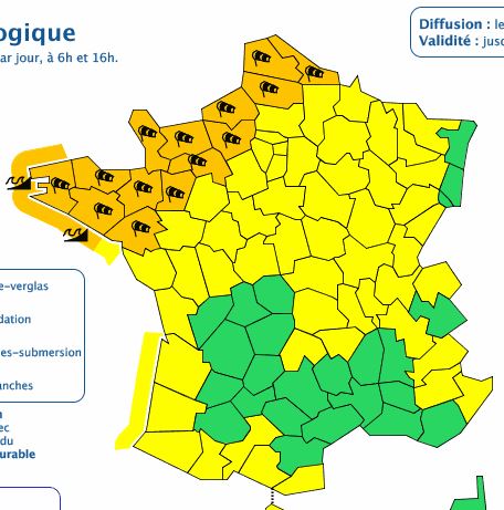
Earlier residents of the north west of France were braced for severe gales and possible coastal flooding from Monday through to Tuesday, with 14 departments placed on orange alert – the second-highest threat level available.
The departments of Morbihan, Finistère and Côtes d’Armor had already been placed on alert on Sunday evening, and on Monday morning France’s national meteorological service Météo France added 11 further departments to that list.
An atmospheric depression which struck the north west of Ireland overnight is set to arrive on the west coast of Brittany at around 2pm on Monday, bringing winds of up to 110 km/h inland, 120 km/h on coasts, and 140 km/h on exposed headlands.
At time of writing, Météo France had forecast the orange alert to last until 12pm on Tuesday in the following departments: Finistère, Morbihan, Côtes d’Armor, Loire-Atlantique, Ille-et-Villaine, Mayenne, Orne, Calvados, Manche, Eure, Seine-Maritime, Somme, Pas-de-Calais, and Nord.
Furthermore, expected heavy rainfall on the west coast of Brittany (up to 40 or 50 mm in 24 hours) could combine with waves caused by strong winds and high tide this evening, to cause flooding on the coasts of Morbihan and Finistère, and in low-lying areas, according to Météo France.
Comments
See Also
STORMS LATEST:
- Cross Channel ferry links hit by storms
The stormy weather battering the north of France and the south of the UK forced several Channel ferry crossings to be cancelled on Monday due to rough seas. With winds of 130km/h recorded off the coast of Finistère in Brittany it was inevitable that transport would be disrupted.
LD Lines cancelled boats between Le Havre and Dieppe to Portsmouth on Monday and Tuesday. The 12pm crossing between Saint-Nazaire and Gijon in northern Spain was also cancelled.
Brittany Ferries has also been forced to cancel crossings from St Malo in Brittany and Ouistreham in Normandy to Portsmouth. A departure from Cherbourg to Portsmouth is however set to leave at 10.30pm on Monday.
The service between Roscoff, in Brittany and Plymouth has been cancelled but the crossing from Plymouth to St Malo will continue as scheduled on Monday.
Earlier residents of the north west of France were braced for severe gales and possible coastal flooding from Monday through to Tuesday, with 14 departments placed on orange alert – the second-highest threat level available.
The departments of Morbihan, Finistère and Côtes d’Armor had already been placed on alert on Sunday evening, and on Monday morning France’s national meteorological service Météo France added 11 further departments to that list.
An atmospheric depression which struck the north west of Ireland overnight is set to arrive on the west coast of Brittany at around 2pm on Monday, bringing winds of up to 110 km/h inland, 120 km/h on coasts, and 140 km/h on exposed headlands.
At time of writing, Météo France had forecast the orange alert to last until 12pm on Tuesday in the following departments: Finistère, Morbihan, Côtes d’Armor, Loire-Atlantique, Ille-et-Villaine, Mayenne, Orne, Calvados, Manche, Eure, Seine-Maritime, Somme, Pas-de-Calais, and Nord.
Furthermore, expected heavy rainfall on the west coast of Brittany (up to 40 or 50 mm in 24 hours) could combine with waves caused by strong winds and high tide this evening, to cause flooding on the coasts of Morbihan and Finistère, and in low-lying areas, according to Météo France.
Join the conversation in our comments section below. Share your own views and experience and if you have a question or suggestion for our journalists then email us at [email protected].
Please keep comments civil, constructive and on topic – and make sure to read our terms of use before getting involved.
Please log in here to leave a comment.